
Drem


Enclosure (Period Unassigned)
Site Name Drem
Classification Enclosure (Period Unassigned)
Canmore ID 77171
Site Number NT57NW 97
NGR NT 50199 79495
Datum OSGB36 - NGR
Permalink http://canmore.org.uk/site/77171


- Council East Lothian
- Parish Athelstaneford
- Former Region Lothian
- Former District East Lothian
- Former County East Lothian
NT57NW 97 NT 50199 79495
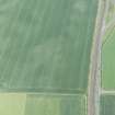
Aerial photography has revealed the cropmarks of a ditched enclosure 630m W of Drem farmsteading (NT57NW 78). It is sub-circular in shape, with a diameter of about 32m, and no clear entrances. A number of indeterminate marks are visible internally. Cropmarks, including those of three enclosures and a ring-ditch have been recorded across the S half of the same field (NT57NEW 42, 108-110).
Information from RCAHMS (KB) 16 December 1999

