
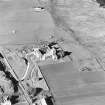
Iona, Port An Diseart


No Class (Event) (Period Unassigned)
Site Name Iona, Port An Diseart
Classification No Class (Event) (Period Unassigned)
Canmore ID 77115
Site Number NM22SE 55
NGR NM 2895 2472
Datum OSGB36 - NGR
Permalink http://canmore.org.uk/site/77115


- Council Argyll And Bute
- Parish Kilfinichen And Kilvickeon
- Former Region Strathclyde
- Former District Argyll And Bute
- Former County Argyll
NM22SE 55 NM 2895 2472
Port an Diseart, Iona
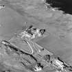
Trial Excavation
During an archaeological evaluation of a proposed pipeline route in January 1993 a trench was sunk to examine one of several raised disc shaped features, 15-20m in diameter, much drier than the surrounding boggy ground. The feature tested had no archaeological significance, with the trench bottoming out at 0.25m where a natural outcrop of rock lay close to the surface, creating the surface feature.
(MS/725/31, GUARD 116)
Trial Trench (January 1993)
During an archaeological evaluation of a proposed pipeline route in January 1993 a trench was sunk to examine one of several raised disc shaped features, 15-20m in diameter, much drier than the surrounding boggy ground. The feature tested had no archaeological significance, with the trench bottoming out at 0.25m where a natural outcrop of rock lay close to the surface, creating the surface feature.
(MS/725/31, GUARD 116)

