
Pricing Change
New pricing for orders of material from this site will come into place shortly. Charges for supply of digital images, digitisation on demand, prints and licensing will be altered.
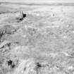
Torr A' Bhathaich


Township (Period Unassigned)
Site Name Torr A' Bhathaich
Classification Township (Period Unassigned)
Canmore ID 7698
Site Number ND05NW 13
NGR ND 038 574
NGR Description Centred ND 038 574
Datum OSGB36 - NGR
Permalink http://canmore.org.uk/site/7698


- Council Highland
- Parish Reay
- Former Region Highland
- Former District Caithness
- Former County Caithness
ND05NW 13 centred 038 574.
(Area: ND 038 574) A group of about five buildings shown in this area.
W Roy 1747-55.
Depopulated area: Torr a' Bhathaich and Torr a' Mhuilinn. An extensive depopulated area with many house and enclosure foundations, towards the S end of which are the remains of three corn-drying kilns (at ND 0393 5715, ND 0401 5740, and ND 0403 5698).
Visited by OS (E G C) 11 April 1961.
No change to the previous field report.
Visited by OS (J B) 21 July 1981.
A township comprising three roofed buildings, one partially roofed building, nineteen unroofed buildings, of which thirteen are long buildings, and seven enclosures is depicted on the 1st edition of the OS 6-inch map (Caithness 1877, sheet xvi). Three roofed, twenty-seven unroofed and nine enclosures are shown on the current edition of the OS 1:10,560 map (1963).
Information from RCAHMS (AKK) 15 September 1995.

