
Ulva


Lazy Beds (Post Medieval), Rig And Furrow (Medieval) - (Post Medieval), Township (Period Unassigned)
Site Name Ulva
Classification Lazy Beds (Post Medieval), Rig And Furrow (Medieval) - (Post Medieval), Township (Period Unassigned)
Alternative Name(s) Kilvickeweniochdrach
Canmore ID 76941
Site Number NM33NE 4.01
NGR NM 3890 3920
NGR Description NM 3890 3920 to 3980 3910
Datum OSGB36 - NGR
Permalink http://canmore.org.uk/site/76941


- Council Argyll And Bute
- Parish Kilninian And Kilmore
- Former Region Strathclyde
- Former District Argyll And Bute
- Former County Argyll
NM33NE 4.01 centred on 3890 3920
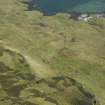
The remains of a deserted township consisting of about nineteen roofless buildings and other enclosures.
Visited by OS (DWR) 11 May 1972
Name given as Kilvickeweeniochdrach.
R Douglas and M M Douglas 1992
(previously recorded as NM43NW 18)
NM 402 390. A depopulated settlement consisting of one roofed and about seven unroofed buildings and other enclosures.
Visited by OS 11 May 1972
A crofting township comprising twenty-five unroofed buildings, one of which is a long building, and two enclosures is depicted on the 1st edition of the OS 6-inch map (Argyllshire, Island of Mull 1881, sheet lxxxi). Thirty-one unroofed buildings and four enclosures are shown on the current edition of the OS 1:10000 map (1975).
Information from RCAHMS (SAH) 29 June 1998

