
Fullerton


Rig And Furrow (Medieval) - (Post Medieval), Ring Ditch (Period Unassigned)
Site Name Fullerton
Classification Rig And Furrow (Medieval) - (Post Medieval), Ring Ditch (Period Unassigned)
Alternative Name(s) Cairnhall
Canmore ID 76936
Site Number NJ71NE 98
NGR NJ 7846 1798
Datum OSGB36 - NGR
Permalink http://canmore.org.uk/site/76936


- Council Aberdeenshire
- Parish Kintore
- Former Region Grampian
- Former District Gordon
- Former County Aberdeenshire
NJ71NE 98 7846 1798
For other cropmark sites nearby seee:
NJ71NE 74 7843 1797 Fullerton enclosure
NJ71NE 75 7838 1817 Fowlertown Cottage enclosure
NJ71NE 96 7836 1797 Fullerton pit-alignment
NJ71NE 97 781 184 Fullerton fort; ring-ditches
NJ71NE 100 7830 1780 Fullerton enclosure
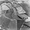
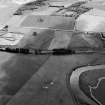
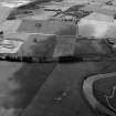
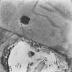
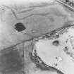
(Location cited as NJ 784 179). Fullerton. Air photography (AAS/89/10/S32/9-11, 14-15) has recorded cropmarks (including that of a ring-ditch) in arable ground on the E-facing terrace of the River Don at an altitude of about 60m OD.
NMRS, MS/712/36.

