Accessibility

Font Size

100% 150% 200%

Background Colour

Default Contrast
Close Reset

Mill Of Kincraigie

Barrow (Prehistoric), Pit(S) (Period Unassigned)

Site Name Mill Of Kincraigie

Classification Barrow (Prehistoric), Pit(S) (Period Unassigned)

Alternative Name(s) Mill Of Knicraggie

Canmore ID 76920

Site Number NJ50SW 19

NGR NJ 50446 03935

Datum OSGB36 - NGR

Permalink http://canmore.org.uk/site/76920

Ordnance Survey licence number AC0000807262. All rights reserved.
Canmore Disclaimer. © Bluesky International Limited 2025. Public Sector Viewing Terms

Toggle Aerial | View on large map

Digital Images

Oblique aerial view centred on the cropmarks of the barrow and pits at Mill of Kincraigie, looking to the NE.
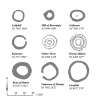
Oblique aerial view centred on the cropmarks of the barrow and pits at Mill of Kincraigie, looking to the NE.Oblique aerial view centred on the cropmarks of the barrow and pits at Mill of Kincraigie, looking to the E.Oblique aerial view centred on the cropmarks of the barrow and pits at Mill of Kincraigie, looking to the SSE.Oblique aerial view centred on the cropmarks of the barrow and pits at Mill of Kincraigie, looking to the SSW.A plan of a selection of ring-ditches identified from cropmarks and two comparable enclosures with external banks recorded at Nether Towie and Wormy Hillock.

Administrative Areas

  • Council Aberdeenshire
  • Parish Tarland
  • Former Region Grampian
  • Former District Kincardine And Deeside
  • Former County Aberdeenshire

Archaeology Notes

NJ50SW 19 50446 03935

Scheduled as Mill of Kincraggie at NJ 503 038.

Information from Historic Scotland, scheduling document dated 21 December 1999.

(Location amended to NJ 5040 0394). Air photography (AAS 1984 and 1989) has recorded the crop- and soilmarks of a ring-ditch (measuring 13m in diameter and with a dark blob) and the cropmarks of field boundaries in flat ground at an altitude of 145m OD.

(Air photographic imagery: AAS/84/8-10/R20/6-7, AAS/84/9-10/R21/(2)/1 and AAS/84/9-10/R21(1)/16, all flown 30 July 1984, and AAS/89/05/S15/10-12, flown 18 July 1989).

[1:2500 map extract supplied].

NMRS, MS/712/91.

References

MyCanmore Image Contributions


Contribute an Image

MyCanmore Text Contributions