
Inchtuthil


Pit Circle (Prehistoric)(Possible), Timber Circle (Neolithic) - (Bronze Age)(Possible)
Site Name Inchtuthil
Classification Pit Circle (Prehistoric)(Possible), Timber Circle (Neolithic) - (Bronze Age)(Possible)
Alternative Name(s) Inchtuthil Plateau
Canmore ID 76907
Site Number NO13NW 39
NGR NO 12414 39342
Datum OSGB36 - NGR
Permalink http://canmore.org.uk/site/76907


- Council Perth And Kinross
- Parish Caputh
- Former Region Tayside
- Former District Perth And Kinross
- Former County Perthshire
Aerial Photographic Interpretation (9 December 1992)
NO13NW 39 1241 3934
See also NO13NW 35.
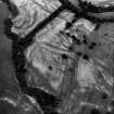
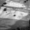
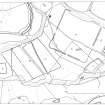
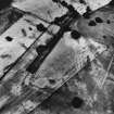
Air photography has revealed the cropmarks of a pit-circle on the Inchtuthil plateau about 70m E of the pit-circle NO13NW 35 and 150m S of the Roman fortress NO13NW 5.00. It measures abut 6m in diameter and comprises thirteen close-set pits.
Information from RCAHMS (JRS) 9 December 1992.
Aerial Photographic Interpretation (20 December 2013)
This pit circle may represent the remains of a ceremonial timber circle.
Information from RCAHMS (KMM) 20 December 2013

