
Pricing Change
New pricing for orders of material from this site will come into place shortly. Charges for supply of digital images, digitisation on demand, prints and licensing will be altered.
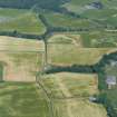
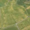
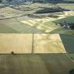
Bellevue


Linear Feature (Period Unassigned), Road (Period Unassigned)(Possible)
Site Name Bellevue
Classification Linear Feature (Period Unassigned), Road (Period Unassigned)(Possible)
Canmore ID 76580
Site Number NH54NW 51
NGR NH 5407 4883
Datum OSGB36 - NGR
Permalink http://canmore.org.uk/site/76580


- Council Highland
- Parish Urray (Ross And Cromarty)
- Former Region Highland
- Former District Ross And Cromarty
- Former County Ross And Cromarty
NH54NW 51 540 488
A broad cropmark, c. 3m wide, which continues the line of the road from Bellevue to the NW, is visible on aerial photographs. (See Archive for details.)
Information from J Harden 1989.

