
'Castlehill'


Enclosure (Period Unassigned)(Possible), Motte (Medieval)(Possible), Pit(S) (Period Unassigned), Ring Ditch (Period Unassigned)(Possible)
Site Name 'Castlehill'
Classification Enclosure (Period Unassigned)(Possible), Motte (Medieval)(Possible), Pit(S) (Period Unassigned), Ring Ditch (Period Unassigned)(Possible)
Alternative Name(s) Castle Hill
Canmore ID 76553
Site Number NJ52NW 40
NGR NJ 5120 2835
NGR Description NJ c. 513 282
Datum OSGB36 - NGR
Permalink http://canmore.org.uk/site/76553


- Council Aberdeenshire
- Parish Auchindoir And Kearn
- Former Region Grampian
- Former District Gordon
- Former County Aberdeenshire
NJ52NW 40 c. 513 282
See also NJ52NW 41.
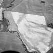
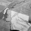
(Location cited as NJ 5130 2820). Possible incomplete motte.
[No historical source specified].
NMRS, MS/712/52.
There is no trace of a motte at this location. Castlehill Farm probably takes its name from a large natural hillock at the confluence of the Kearn Burn and Bogie Water about 350m N of the steading (NJ52NW 69). Aerial photography has revealed the cropmarks of a possible enclosure (NJ52NW 41) on the hillock.
Visited by RCAHMS (JRS), 27 March 2000.

