
Pricing Change
New pricing for orders of material from this site will come into place shortly. Charges for supply of digital images, digitisation on demand, prints and licensing will be altered.
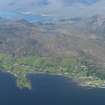
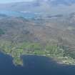
Slumbay Island


Building(S) (Period Unassigned), Wall (Period Unassigned)
Site Name Slumbay Island
Classification Building(S) (Period Unassigned), Wall (Period Unassigned)
Canmore ID 76489
Site Number NG83NE 8
NGR NG 896 386
Datum OSGB36 - NGR
Permalink http://canmore.org.uk/site/76489


- Council Highland
- Parish Lochcarron
- Former Region Highland
- Former District Ross And Cromarty
- Former County Ross And Cromarty
NG83NE 8 896 386.
'N-S across E end of promontory are traces of heavy built walls surmounting terrace slopes. On N side of old look-out station D-shaped outline 11 x 16m. The W side of the promonoty is a sheer cliff. On lower ground two longhouses: one on shore NE side 4-roomed 19 x 5m, the other on isthmus 2-roomed 9 x 6m.'
T C Welsh 1974d.

