
Blackwater Reservoir, Aqueduct


Aqueduct (20th Century)
Site Name Blackwater Reservoir, Aqueduct
Classification Aqueduct (20th Century)
Alternative Name(s) Kinlochleven Hydroelectric Power Scheme; Kinlochleven Aluminium Works, Pipeline; Blackwater Reservoir, Conduit
Canmore ID 76447
Site Number NN26SW 3.01
NGR NN 22768 60205
NGR Description NN 24731 60260 to NN 20214 60445
Datum OSGB36 - NGR
Permalink http://canmore.org.uk/site/76447


- Council Highland
- Parish Lismore And Appin (Lochaber)
- Former Region Highland
- Former District Lochaber
- Former County Argyll
NN26SW 3.01 22768 60205
Extends onto map sheet NN25NW.
Location formerly cited as NN 191 617 to NN 202 604, and NN 2004 6067.
Conduit [NAT] (at NN 2090 6011)
Conduit [NAT] (at NN 2182 6010)
Conduit [NAT] (at NN 2338 6048)
Conduit [NAT] (at NN 2452 6022)
OS 1:10,560 map, 1968.
Conduit [NAT] (centred NN 2231 5981)
OS 1:10,000 map, 1992.
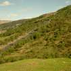
The course of a rail-bed, following the S side of the pipeline from the Blackwater Dam (NN26SW 3.00) was observed during a pre-afforestation survey by AOC (Scotland Ltd). The tracks are set into concrete and are 0.5m apart. A pylon beside the track suggests that there was originally an overhead cable. The pylon stands 6.5m in height and consists of two uprights which are 3m apart and a cross bar carrying winch gear. There is a 5m long brace extending from the pylon into the hillside above the rail line. It is situated immediately W of the buildings where the open conduit changes into a pipeline.
C Burgess (AOC (Scotland Ltd)) March 1996; NMRS MS 738/31 no. 62 (56/1-2).
The location assigned to this record is arbitrary. The available (GIS) map evidence depicts this structure as extending from NN 24731 60260 to NN 20214 60445, along the S side of the upper valley of the River Leven.
This aqueduct carried water for power generation at the Kinlochleven Aluminium Works (NN16SE 3.00) from the Blackwater Dam (NN26SW 3.00) to the lower penstock house (NN26SW 3.03), where it entered the pipeline NN16SE 1. Numerous small aqueducts and sluices control the relationship of the aqueduct with streams flowing downhill (from the S). These await detailed recording.
Information from RCAHMS (RJCM), 9 June 2006.
Field Visit (2010)
This closed concrete aqueduct carries water from the Blackwater Dam outlet downhill to the penstock inlets. It is a closed U section waterway made from concrete. It is predominantly on or just under the ground, although in some sections it is bourn on an arcade of concrete arches across small streams. This is a significant linear feature with some subterranean sections. It is functionally linked to the scheme. The arched sections which convey the aqueduct across uneven sections of ground are of technical interest as early examples of the use of reinforced concrete. P L Payne, 1988; E Wood, 2002; Concrete and Constructional Engineering IV, 1909; Alcan, n.d., The Lochaber Water Power Scheme.

