
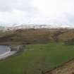
Ardnamurchan, Camas Nan Geall


Cruck Framed Cottage (Post Medieval), Cultivation Remains (Period Unassigned), Township (Period Unassigned)
Site Name Ardnamurchan, Camas Nan Geall
Classification Cruck Framed Cottage (Post Medieval), Cultivation Remains (Period Unassigned), Township (Period Unassigned)
Alternative Name(s) Cladh Chiarain
Canmore ID 76259
Site Number NM56SE 7
NGR NM 559 619
NGR Description Centred NM 559 619
Datum OSGB36 - NGR
Permalink http://canmore.org.uk/site/76259


- Council Highland
- Parish Ardnamurchan
- Former Region Highland
- Former District Lochaber
- Former County Argyll
NM56SE 7 centred 559 619
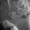
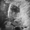
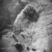
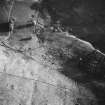
There are the ruins of numbers of cottages on both sides of Camus nan Geall.
M E M Donaldson 1923
Mackenzie mentions four townships in the Ben Hiant area depopulated in 1828: Coire-mhuilinn (NM56SW 4); Bourblaige (NM56SW 2); Tornamona (NM56SE 4) and Skinid (not named on OS maps). (Possibly this last name could apply to the township here?)
A MacKenzie 1946
Cruck-slots noted.
G Stell 1981
The building at NM 5587 6199 and another at NM 5590 6204 now shown as abandoned were shown as roofed in 1875. No buildings were shown in this position on Bald's map of 1806 and they are likely to have been built when the land was being used for sheep farming after the clearances of 1828. Two buildings and their enclosures are shown as unroofed at NM 5601 6165 in 1875 together with another building at NM 5598 6160. A fourth at NM 5597 6161 was then unroofed. These are likely to be cottars or fishermens cottages lying on Ardslignish Farm. This has been a desk assessment area.
J Wordsworth, SSSIs, Scottish Natural Heritage, 1993
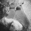
Five unroofed, seven roofed buildings, four enclosures and a Graveyard [NM56SE 2] are depicted on the 1st edition of the OS 6-inch map (Argyllshire 1875, sheet xxv). Eight unroofed buildings, three enclosures, one of which is incomplete, and the Graveyard are shown on the current edition of the OS 1:10000 map (1974).
Information from RCAHMS (SAH) 6 May 1998
Excavation (8 September 2019 - 20 September 2019)
NM 55995 61977 The first season of the field school focused on the bay at Camas Nan Geall on the south coast of Ardnamurchan. The work was completed by students, local volunteers from AHHA and supervised by staff from Archaeology Scotland and HARP, and comprised excavation, historic building recording, and walkover field survey.
Prior to any fieldwork taking place, a desk-based assessment of the bay was undertaken by Archaeology Scotland on behalf of AHHA, in order to create a baseline understanding of the heritage of the bay. The desk-based assessment collated information from national and local databases, together with cartographic material, modern satellite imagery, and other bibliographic sources, in particular, information from AHHA and their own work within the Bay. The majority of the sites identified with the bay relate to the former township of Camas nan Geall (Canmore ID: 76259).
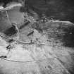
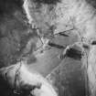
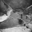
Excavation was targeted on one of the surviving buildings identified as part of the township (Structure 3b.1), which is likely to be of 18th -19th-century date, perhaps associated with tenant sheep farming in the Bay. AHHA describe the building as being of mortared stone wall construction, with square corners and gable ends, and with two compartments. Dense vegetation was removed from the interior of the building prior to excavation commencing, which revealed substantial rubble collapse from the gable ends and other structural walls of the building.
A total of four trenches (Trenches 1-4) were excavated, largely only resulting in the removal of topsoil and the recording of the first archaeological horizon encountered below. Trench 1, measuring 2.5 x 2.5m extended across both the interior and exterior of the building, coming through the building’s entrance on the southern wall. Areas of tumble and collapse were recorded, together with possible interior floor remains, and a paved stone platform associated with a gravel metalled surface located on the exterior of the building. The latter is thought to be the remains of a trackway depicted on the OS 2nd Edition map. Trench 2, measuring 2.5 x 2m was located on the north-eastern interior of the building. Large amounts of wall collapse were recorded, together with a possible cobbled surface on the western side of the trench. Trench 3, measuring 2 x 2m, was located on the south-eastern interior of the building, adjacent to the remains of an internal wall. Wall collapse from the internal and main external building wall were recorded. Trench 4, measuring 2.5 x 2m was located on the south-western corner of the exterior of the building. Wall tumble was recorded together with a continuation of the paved stone platform recorded in Trench 1, and an area of stones extending out of the trench in the SW corner-perhaps the remains of a separate exterior structure. Numerous finds were identified and retained, mostly appearing to be 19th-20th century in date and largely from the topsoil and tumble/collapse deposits.
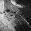
Historic building recording of Structure 3b.1 was also undertaken, with a general photographic and written description of the building being completed followed by detailed photographic, drawn and written recording of the eastern external elevation.
The field survey focused on the recorded township area on the western side of the bay (Site 3a), and nearby foreshore and lower slopes of the bay in this area. Records of previously identified elements of the township were enhanced, and several new features and sites were identified, including two possible boat nousts, a large sub-oval structure/building, a circular structure (perhaps an animal pen or hut circle), and a possible cairn. Additional field survey was undertaken around structure 3b.1, part of the 3b township area.
Archive: NRHE (intended)
Funder: Archaeology Scotland
Phil Richardson, Rebacca Barclay, Héléna Gray, Kieran Manchip, Iain Pringle and Ian Hill - Archaeology Scotland, Ardnamurchan History and Heritage Association (AHHA) and Heritage and Archaeological Research Practice (HARP)
(Source: DES Vol 20)

