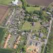
Accessibility

Font Size

100% 150% 200%

Background Colour

Default Contrast
Close Reset

Innerwick, General

Burgh (Medieval), Village (Period Unassigned)

Site Name Innerwick, General

Classification Burgh (Medieval), Village (Period Unassigned)

Canmore ID 76235

Site Number NT77SW 62

NGR NT 71998 73969

NGR Description Centred on NT 71998 73969

Datum OSGB36 - NGR

Permalink http://canmore.org.uk/site/76235

Ordnance Survey licence number AC0000807262. All rights reserved.
Canmore Disclaimer. © Bluesky International Limited 2025. Public Sector Viewing Terms

Toggle Aerial | View on large map

Digital Images

General oblique aerial view of Innerwick centred on Innerwick Parish Church, taken from the W.
General oblique aerial view of Innerwick centred on Innerwick Parish Church, taken from the W.General oblique aerial view of Innerwick centred on Innerwick Parish Church, taken from the WSW.

Administrative Areas

  • Council East Lothian
  • Parish Innerwick (East Lothian)
  • Former Region Lothian
  • Former District East Lothian
  • Former County East Lothian

Archaeology Notes

NT77SW 62 72 73.

Licensed as burgh of barony, 1630.

G S Pryde 1965.

References

MyCanmore Image Contributions


Contribute an Image

MyCanmore Text Contributions