
Pricing Change
New pricing for orders of material from this site will come into place shortly. Charges for supply of digital images, digitisation on demand, prints and licensing will be altered.
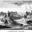
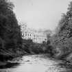
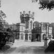
Calderwood Castle


Tower House (Medieval)
Site Name Calderwood Castle
Classification Tower House (Medieval)
Canmore ID 76196
Site Number NS65NE 38
NGR NS 66222 55223
NGR Description Centred on NS 66222 55223
Datum OSGB36 - NGR
Permalink http://canmore.org.uk/site/76196


- Council South Lanarkshire
- Parish East Kilbride (South Lanarkshire)
- Former Region Strathclyde
- Former District East Kilbride
- Former County Lanarkshire
NS65NE 38 66222 55223
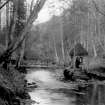
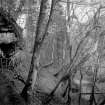
This large rectangular tower house stood in a bend of the Rotten Calder Water until 1773, when it collapsed into the gorge. It was illustrated by MacGibbon and Ross from a drawing of 1765, now in the Royal Scottish Academy, and known locally because of later additions which survived until the present century.
The heavily overgrown site is littered with rubble and there are signs of structural remains of indeterminate age.
D MacGibbon and T Ross 1892; Strathclyde Regional Council 1991.
NMRS REFERENCE
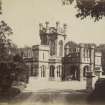
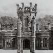
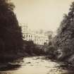
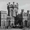
'Calderwood Castle' the country house was depicted on the OS 2nd Edition map (Lanarkshire, XVII 2, 1939). It has since been demolished. Information from RCAHMS (KD), December 2001.
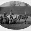
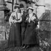
Photographic Record (1885)
Photographs in album titled 'Views in Busby, East-Kilbride, Carmunnock, Mearns, Eaglesham, and their vicinity 1885'

