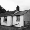
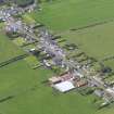
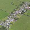
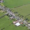
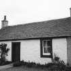
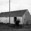
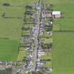
Accessibility

Font Size

100% 150% 200%

Background Colour

Default Contrast
Close Reset

Ruthwell, General

Burgh (Medieval), Village (Period Unassigned)

Site Name Ruthwell, General

Classification Burgh (Medieval), Village (Period Unassigned)

Canmore ID 76185

Site Number NY16NW 39

NGR NY 1000 6740

NGR Description Centred on NY 1000 6740

Datum OSGB36 - NGR

Permalink http://canmore.org.uk/site/76185

Ordnance Survey licence number AC0000807262. All rights reserved.
Canmore Disclaimer. © Bluesky International Limited 2025. Public Sector Viewing Terms

Toggle Aerial | View on large map

Digital Images

General view of cottage.
General view of cottage.General oblique aerial view of Ruthwell, taken from the SE.General oblique aerial view of Ruthwell, taken from the WSW.General oblique aerial view of Ruthwell, taken from the SE.General view of cottage.General view of cottage.General view of shed.General oblique aerial view of Ruthwell, taken from the WNW.

Administrative Areas

  • Council Dumfries And Galloway
  • Parish Ruthwell
  • Former Region Dumfries And Galloway
  • Former District Nithsdale
  • Former County Dumfries-shire

Archaeology Notes

NY16NW 39 10 67

Erected burgh of barony 1507/8.

G S Pryde 1965

References

MyCanmore Image Contributions


Contribute an Image

MyCanmore Text Contributions