
Pricing Change
New pricing for orders of material from this site will come into place shortly. Charges for supply of digital images, digitisation on demand, prints and licensing will be altered.
Upcoming Maintenance
Please be advised that this website will undergo scheduled maintenance on the following dates:
Thursday, 9 January: 11:00 AM - 3:00 PM
Thursday, 23 January: 11:00 AM - 3:00 PM
Thursday, 30 January: 11:00 AM - 3:00 PM
During these times, some functionality such as image purchasing may be temporarily unavailable. We apologise for any inconvenience this may cause.
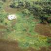
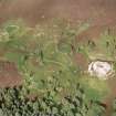
Backies


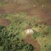
Farmstead (Period Unassigned), Field System (Period Unassigned)
Site Name Backies
Classification Farmstead (Period Unassigned), Field System (Period Unassigned)
Canmore ID 76117
Site Number NC80SW 33.27
NGR NC 8338 0279
Datum OSGB36 - NGR
Permalink http://canmore.org.uk/site/76117


- Council Highland
- Parish Golspie
- Former Region Highland
- Former District Sutherland
- Former County Sutherland
NC80SW 33.27 8338 0279
(Previously NC80SW 44)
A farmstead comprising two roofed buildings and two enclosures, and a field are depicted on the 1st edition of the OS 6-inch map (Sutherland 1876, sheet cv). One roofed building, an enclosure and a field are shown on the current edition of the OS 1:10,560 map (1969).
Information from RCAHMS (SAH) 15 January 1996

