
Pricing Change
New pricing for orders of material from this site will come into place shortly. Charges for supply of digital images, digitisation on demand, prints and licensing will be altered.
Springburn


Roundhouse(S) (Prehistoric)
Site Name Springburn
Classification Roundhouse(S) (Prehistoric)
Alternative Name(s) Deer's Den; Kintore
Canmore ID 76092
Site Number NJ71NE 92
NGR NJ 78421 16056
NGR Description Centred NJ 78421 16056
Datum OSGB36 - NGR
Permalink http://canmore.org.uk/site/76092


- Council Aberdeenshire
- Parish Kintore
- Former Region Grampian
- Former District Gordon
- Former County Aberdeenshire
NJ71NE 92 centred 784210 16056
Location formerly entered as NJ 7844 1603
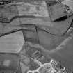
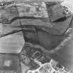
(NGR originally NJ 7826 1599) Ring-ditch, visible on air photographs.
M Greig 1992.
Air photography (AAS/92/04/G2/17, flown 16 July 1992) has revealed a ring-ditch on a gentle SE-facing slope at an altitude of 55m OD. Further air survey (AAS/95/08/G24/4-13, flown 15 August 1995) has revealed at least nine huts (running in a line from E to W) with what may be others further to the W.
Information from Aberdeenshire Archaeological Service, June 1997.
NMRS, MS/712/19 and MS/712/36.
Scheduled as 'Deer's Den, roundhouses 195m and 250m S of... the cropmarked remains of at least seven roundhouses... in pasture to the west of the A96 trunk road at Kintore...'
[Scheduling map indicates location at Centred NJ 78380 16033].
Information from Historic Scotland, scheduling document dated 30 March 2009.

