|
Manuscripts |
MS 60 |
|
Lists of houses of historic interest compiled by I G Lindsay and the Marquess of Bute.
National Trust list index, 1940.
Provisional list of towns visited, 1936.
Lists and photocopied plans, 1936.
Original town maps, 1936. |
1936 |
Item Level |
|
|
Photographs and Off-line Digital Images |
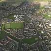
E 55031 CN |
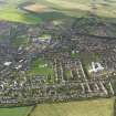
RCAHMS Aerial Photography |
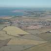
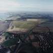
General oblique aerial view looking across the school, town and restored agricultural land towards Longniddry and North Berwick Law, taken from the WSW. |
17/2/2005 |
Item Level |
|
|
Photographs and Off-line Digital Images |
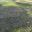
E 55032 CN |
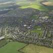
RCAHMS Aerial Photography |
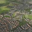
General oblique aerial view looking across the school, town and restored agricultural land towards Longniddry and North Berwick Law, taken from the SW. |
17/2/2005 |
Item Level |
|
 |
On-line Digital Images |
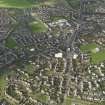
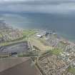
DP 008807 |
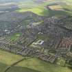
RCAHMS Aerial Photography Digital |
General oblique aerial view of the town looking towards the East Lothian coastline, taken from the SW. |
11/7/2005 |
Item Level |
|
 |
On-line Digital Images |
DP 073658 |
RCAHMS Aerial Photography Digital |
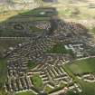
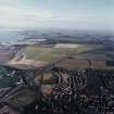
General oblique aerial view centred on town, taken from the S. |
4/11/2009 |
Item Level |
|
 |
On-line Digital Images |
DP 073659 |
RCAHMS Aerial Photography Digital |
General oblique aerial view centred on town, taken from the SSE. |
4/11/2009 |
Item Level |
|
 |
On-line Digital Images |
DP 073660 |
RCAHMS Aerial Photography Digital |
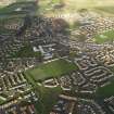
General oblique aerial view centred on part of the town, taken from the SSE. |
4/11/2009 |
Item Level |
|
 |
On-line Digital Images |
DP 073661 |
RCAHMS Aerial Photography Digital |
General oblique aerial view centred on town, taken from the SE. |
4/11/2009 |
Item Level |
|
 |
On-line Digital Images |
DP 073662 |
RCAHMS Aerial Photography Digital |
General oblique aerial view centred on town, taken from the SE. |
4/11/2009 |
Item Level |
|
 |
On-line Digital Images |
DP 073663 |
RCAHMS Aerial Photography Digital |
General oblique aerial view centred on part of the town, taken from the ESE. |
4/11/2009 |
Item Level |
|
 |
On-line Digital Images |
DP 073664 |
RCAHMS Aerial Photography Digital |
General oblique aerial view centred on town, taken from the ESE. |
4/11/2009 |
Item Level |
|
 |
On-line Digital Images |
DP 073665 |
RCAHMS Aerial Photography Digital |
General oblique aerial view centred on town, taken from the S. |
4/11/2009 |
Item Level |
|
 |
On-line Digital Images |
DP 073666 |
RCAHMS Aerial Photography Digital |
General oblique aerial view centred on town, taken from the E. |
4/11/2009 |
Item Level |
|
 |
On-line Digital Images |
DP 073667 |
RCAHMS Aerial Photography Digital |
General oblique aerial view centred on town, taken from the NE. |
4/11/2009 |
Item Level |
|
|
Photographs and Off-line Digital Images |
D 39991 |
Frank Mears and Partners |
Map titled Prestonpans Tranent Community. |
|
Item Level |
|
 |
On-line Digital Images |
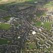
DP 138826 |
Records of CFA Archaeology Ltd, archaeologists, Musselburgh, East Lothian, Scotland |
View of Tranent from the N. |
10/2008 |
Item Level |
|
 |
On-line Digital Images |
DP 153445 |
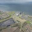
RCAHMS Aerial Photography Digital |
General oblique aerial view of Cockenzie and Tranent environs centred on Cockenzie Power Sataion, looking to the W. |
1/5/2013 |
Item Level |
|
 |
On-line Digital Images |
DP 153446 |
RCAHMS Aerial Photography Digital |
General oblique aerial view of Cockenzie and Tranent environs centred on Cockenzie Power Sataion, looking to the W. |
1/5/2013 |
Item Level |
|
|
Prints and Drawings |
DC 64739 |
Royal Incorporation of Architects in Scotland |
Stalls level and mezzanine floor plans of proposed alterations at the Picture House, Tranent. |
4/1937 |
Item Level |
|
|
Prints and Drawings |
DC 64740 |
Royal Incorporation of Architects in Scotland |
Plans of operations room, balcony and longitudinal section of proposed alterations at the Picture House, Tranent. |
4/1937 |
Item Level |
|
|
Prints and Drawings |
DC 64741 |
Royal Incorporation of Architects in Scotland |
Elevations and sections of proposed alterations at the Picture House, Tranent. |
4/1937 |
Item Level |
|
 |
On-line Digital Images |
SC 1680398 |
RCAHMS Aerial Photography |
General oblique aerial view looking across the school, town and restored agricultural land towards Longniddry and North Berwick Law, taken from the WSW. |
17/2/2005 |
Item Level |
|
 |
On-line Digital Images |
SC 1680399 |
RCAHMS Aerial Photography |
General oblique aerial view looking across the school, town and restored agricultural land towards Longniddry and North Berwick Law, taken from the SW. |
17/2/2005 |
Item Level |
|


