
Belses Station


Railway Station (19th Century)
Site Name Belses Station
Classification Railway Station (19th Century)
Alternative Name(s) The Waverley Line; New Belses Station; Edinburgh To Hawick Branch Railway
Canmore ID 76019
Site Number NT52NE 24.01
NGR NT 57402 25191
Datum OSGB36 - NGR
Permalink http://canmore.org.uk/site/76019


- Council Scottish Borders, The
- Parish Ancrum
- Former Region Borders
- Former District Roxburgh
- Former County Roxburghshire
NT52NE 24.01 57402 25191
The Object Name Book of the Ordnance Survey (ONB) describes 'Belses Station' as A two storey house the upper flat of which is used for a railway station, it is situated at New Belses and is the property of the North British Railway Company'.
Name Book 1858
Belses had fewer facilties than Stow Station (see NT44SE 28.11). It had two trailing crossovers. There was no goods station. There were station buildings at NT57373 25186 and NT57386 25179; weighting machine at NT57381 25167; Signal Box at NT57329 25093; crane at NT57366 25123 and a loading bank with spur at NT57356 25114.
D Evans 1985.
This intermediate station on the Edinburgh-Carlisle (main) line ('the 'Waverley route') of the North British Rly. was opened on 1 November 1849 as New Belses station and renamed Belses station in July 1862; it closed to regular passenger traffic (with the line as a whole) on 6 January 1969.
R V J Butt 1995.
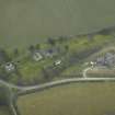
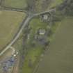
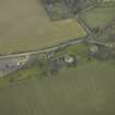
Belses Station is situated on an embankment between two road underbridges about 200m SE of New Belses farmsteading.
The station buildings survive on both the up and down platforms. That on the down platform is of brick and wood with a slated roof whilst the up platform building also with a slated roof is now a private dwelling house. The footbridge has been removed.
The road underbridge (NT52NE 24.10), at the NE end has been removed with the embankment having been landscaped and that to the SW ( ) has also been removed.
Visited by RCAHMS (DE), August 2006
Sbc Note
Visibility: This is an upstanding building.
Information from Scottish Borders Council.

