
Pricing Change
New pricing for orders of material from this site will come into place shortly. Charges for supply of digital images, digitisation on demand, prints and licensing will be altered.
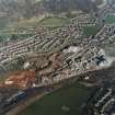
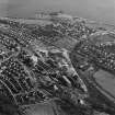
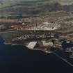
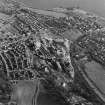
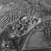
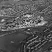
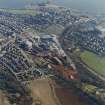
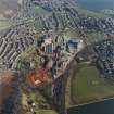
Burntisland, General


Burgh (Medieval), Town (Period Unassigned)
Site Name Burntisland, General
Classification Burgh (Medieval), Town (Period Unassigned)
Canmore ID 75960
Site Number NT28NW 82
NGR NT 2300 8599
Datum OSGB36 - NGR
Permalink http://canmore.org.uk/site/75960


- Council Fife
- Parish Burntisland
- Former Region Fife
- Former District Kirkcaldy
- Former County Fife
NT28NW 82 2300 8599.
Burntisland anciently belonged, as a town and harbour, to the abbey of Dunfermline; it was erected a royal burgh in 1541.
G S Pryde 1965.
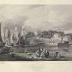
Photographic Survey (1942)
Photographic survey of buildings in Burntisland, Fife c1942 by the National Buildings Record Scottish Council.
Photographic Survey (1954)
Photographs of buildings in Burntisland, Fife, including a survey of Rossend Castle by the Scottish National Buildings Record in 1954.

