
Blockie Head


Fort (Period Unknown)
Site Name Blockie Head
Classification Fort (Period Unknown)
Alternative Name(s) North Haven
Canmore ID 75948
Site Number NK13NW 6
NGR NK 11040 38260
Datum OSGB36 - NGR
Permalink http://canmore.org.uk/site/75948


- Council Aberdeenshire
- Parish Cruden
- Former Region Grampian
- Former District Banff And Buchan
- Former County Aberdeenshire
Field Visit (14 May 1993)
NK13NW 6 1104 3826
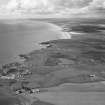
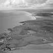
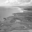
This fort is situated on Blockie Head, a precipitous promontory forming the S side of the entrance into North Haven. The defences, which cut off the landward approach to the promontory, have been partly obscured by the corner of an improved field and the coastal footpath, but arcs of at least three, and possibly four, ditches can be identified, the outermost accompanied by a low internal bank. A central entrance-causeway provided access to the level top of the promontory, which measures 60m in length from ENE to WSW by a maximum of 13m transversely, although for much of its length it is no more than 8m in breadth; in some places, traces of a low bank can be seen along the edge. The fort was first noted in the nineteenth century (Name Book 1872; Pratt 1901), but it was depicted without annotation on the first edition of the OS 6-inch map (Aberdeenshire, 1872, sheet 32), and later removed from the maps entirely.
Visited by RCAHMS (SH) 14 May 1993.
Note (29 April 2015 - 31 May 2016)
The precipitous promontory on the S side of the entrance to North Haven is occupied by a fort defended by at least three and possibly four ditches drawn in an arc across its neck on the WSW. In the central sector the outer ditches have been levelled by cultivation of the adjacent field, and apart from a low internal bank accompanying the outermost, little trace of any of the upcast ramparts remains. Whereas the belt of defences is some 44m in depth, the interior has been heavily eroded, measuring about 60m in length from ENE to WSW but rarely exceeding 8m in breadth, at its widest being no more than 13m (0.08ha). Traces of what is probably a later bank can be seen extending round the margins of the promontory, but the interior is otherwise featureless. The entrance is on the WSW, where a central causeway traverses the ditches.
Information from An Atlas of Hillforts of Great Britain and Ireland – 31 May 2016. Atlas of Hillforts SC2987
Excavation (24 January 2019 - 26 January 2019)
NK 1104 3826 Four trenches and three test pits were excavated, 24-26 January 2019, in the banks and interior of Blockie Head promontory fort (NK13NW 6), which cuts off the Blockie Head promontory, south of Peterhead. This is part of a larger work looking at Scotland’s promontory forts to add to the body of knowledge regarding this enigmatic monument type. The monument consists of at least three ditches cutting of the promontory enclosing an area of around 0.08ha. Excavations were targeted at the outer defensive works and on the interior.
Trench 1 targeted the innermost ditch which proved to be at least 2m deep indicating that the internal bank was at least 4m above the base of the ditch, not accounting for erosion or possible palisades or fences on top of the bank.
Trench 2 was placed over the southern portion of the second ditch. Various clay fills were identified in the ditch along with charcoal from the lower fills which was sampled for dating.
Trench 3 was placed over the entrance area to test for archaeological deposits. This revealed two large postholes, one of which was half sectioned. One posthole was positioned at the NE edge of the trench, with its northern half extending beyond the limits of the excavated area. The excavated posthole measured approximately 0.75m N-S by 0.81m E-W (though the full extent of the feature was not revealed) and was 0.63m deep. Considering their positioning, these posts may represent another defensive element such as a palisade.
Trench 4 was located within the interior around 7m from the entrance. Up to nine postholes were identified in the trench along with a floor layer. Charred roundwood and charcoal found in a 0.3m slot dug on the west side appeared to consist of a burnt wattle layer that had been destroyed by a fire. This layer extended beyond the trench and the full extent was not recorded. Two southern postholes showed scorching and redness on the natural surface indicating in-situ burning. Samples from postholes and the floor layer were retrieved for dating. Four test pits were opened on the eastern side of the fort interior. None produced any archaeological features, but one trench located on the edge of the stack had 19th-century pottery which indicated this, a low bank around the edge of the interior, may be a later feature.
Archive: University of Aberdeen
Funder: University of Aberdeen
Gordon Noble, James O’Driscoll, Jonathan Mosca and Zachary Hinkley – University of Aberdeen
(Source: DES Vol 20)

