
Pricing Change
New pricing for orders of material from this site will come into place shortly. Charges for supply of digital images, digitisation on demand, prints and licensing will be altered.
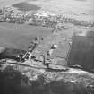
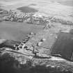
Castlehill Pavement Works, Quarry


Quarry (Period Unassigned)
Site Name Castlehill Pavement Works, Quarry
Classification Quarry (Period Unassigned)
Alternative Name(s) Castletown Quarry
Canmore ID 75688
Site Number ND16NE 42.03
NGR ND 19250 68350
Datum OSGB36 - NGR
Permalink http://canmore.org.uk/site/75688


- Council Highland
- Parish Olrig
- Former Region Highland
- Former District Caithness
- Former County Caithness
ND16NE 42.03 19250 68350
Location formerly cited as ND 19 68.
Castletown Quarry (disused) [NAT]
OS 1:10,560 map, 1970.

