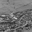
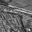
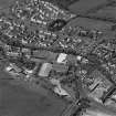
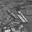
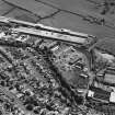
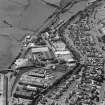
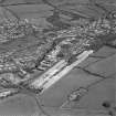
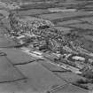
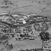
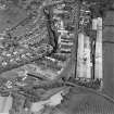
Accessibility

Font Size

100% 150% 200%

Background Colour

Default Contrast
Close Reset

Newmilns

Burgh (Medieval), Town (Period Unassigned)

Site Name Newmilns

Classification Burgh (Medieval), Town (Period Unassigned)

Alternative Name(s) Newmilns And Greenholm

Canmore ID 75550

Site Number NS53NW 35

NGR NS 5360 3731

Datum OSGB36 - NGR

Permalink http://canmore.org.uk/site/75550

Ordnance Survey licence number AC0000807262. All rights reserved.
Canmore Disclaimer. © Bluesky International Limited 2025. Public Sector Viewing Terms

Toggle Aerial | View on large map

Digital Images

General aerial view of Stoneygate Road and Brown Street factories, taken from the NE.
General aerial view of Stoneygate Road and Brown Street factories, taken from the NE.General aerial view of factories on Brown Street, taken from the WNW.Aerial view of Newmilns railway viaduct and factories, centred on the site of Greenhead Mills, taken from the SE.General aerial view of Newmilns and Greenholm, taken from the WNW.General aerial view of Stoneygate Road and Brown Street factories, including the railway bridge, taken from the SSE.General aerial view of Brown Street factories and railway bridge, taken from the WSW.General aerial view of factories on Brown Street and Stoneygate Road, taken from the NW.Aerial view of Newmilns railway viaduct and factories, centred on the site of Greenhead Mills, taken from the SSW.General aerial view of Newmilns railway viaduct and factories, centred on the site of Greenhead Mills, taken from the E.General aerial view of Stoneygate Road and Brown Street factories, including the railway bridge, taken from the NE.Aerial view of Newmilns railway viaduct and factories, centred on Greenhead Mills, taken from the E.Aerial view of Newmilns railway viaduct and factories, centred on Union Street Factory, taken from the NNW.General aerial view of Newmilns railway viaduct and factories, centred on the site of Greenhead Mills, taken from the NE.General aerial view of Brown Street factories and railway bridge, taken from the SSW.General aerial view of factories on Brown Street and Stoneygate Road, taken from the WNW.Aerial view of Newmilns railway viaduct and factories, centred on Union Street Factory, taken from the NE.General aerial view of Brown Street and Stoneygates Road factories, taken from the E.Aerial view of Newmilns railway viaduct and factories, centred on Greenhead Mills, taken from the SSE.Aerial view of Newmilns railway viaduct and factories, centred on Greenhead Mills, taken from the ESE.Aerial view of Newmilns railway viaduct and factories, centred on Greenhead Mills, taken from the E.Aerial view of Newmilns railway viaduct and factories, centred on the site of Greenhead Mills, taken from the NE.Aerial view of Stoneygate Road and Brown Street factories, taken from the S.General aerial view of Brown Street and Stoneygates Road factories, taken from the ENE.Aerial view of Newmilns railway viaduct and factories, centred on Greenhead Mills, taken from the S.General aerial view of Brown Street factories and railway bridge, taken from the WSW.General aerial view of Brown Street factories and railway bridge, taken from the SW.Aerial view of Newmilns railway viaduct and factories, taken from the SE and centred on Greenhead Mills, including the site of Darvel Road Hosiery Works.General aerial view of Newmilns railway viaduct and factories, centred on the site of Greenhead Mills, taken from the ENE.General aerial view of Newmilns and Greenholm, taken from the WSW.General aerial view of Stoneygate Road and Brown Street factories, including the railway bridge, taken from the E.General aerial view of Stoneygate Road and Brown Street factories, taken from the N.General aerial view of factories on Brown Street, taken from the SW.Aerial view of Newmilns railway viaduct and factories, centred on Greenhead Mills, taken from the ENE.Aerial view of Newmilns railway viaduct and factories, centred on the site of Greenhead Mills, taken from the NNW.General aerial view of Newmilns and Greenholm, taken from the NW.General aerial view of Newmilns and Greenholm, taken from the W.General aerial view of Newmilns, taken from the SW.

Administrative Areas

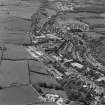
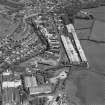
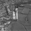
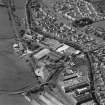
  • Council East Ayrshire
  • Parish Loudoun
  • Former Region Strathclyde
  • Former District Kilmarnock And Loudoun
  • Former County Ayrshire

Archaeology Notes

NS53NW 35 53 37

Eercted burgh of barony, 1490/1; burgh of regality, 1707.

G S Pryde 1965.

Architecture Notes

EXTERNAL REFERENCE:

National Library

Watercolour sketches by Thomas Brown Vol. II, 59 - 1 view.

References

MyCanmore Image Contributions


Contribute an Image

MyCanmore Text Contributions