
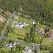
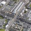
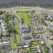
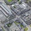
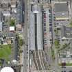
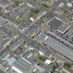
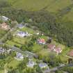
Helensburgh, General


Burgh (Medieval), Town (Period Unassigned)
Site Name Helensburgh, General
Classification Burgh (Medieval), Town (Period Unassigned)
Canmore ID 75481
Site Number NS38SW 18
NGR NS 3000 8250
NGR Description Centred NS 3000 8250
Datum OSGB36 - NGR
Permalink http://canmore.org.uk/site/75481


- Council Argyll And Bute
- Parish Rhu
- Former Region Strathclyde
- Former District Dumbarton
- Former County Dunbartonshire
NS38SW 18 centred 3000 8250
Location formerly entered as NS 30 82.
Erected burgh of barony in 1802.
G S Pryde 1965.
NMRS REFERENCE:
PLANS:
Dick, Peddie & MacKay, Edinburgh new building - Helensburgh Villas, House for Mr. Dick & its neighbour
Bin 3, Bag 2 Peddie & Kinnear 1864
Dick, Peddie & MacKay, Edinburgh Helensburgh villas, feu-plan of Helensburgh, property of James
Colquhoun, bart.
Bin 3, Bag 2 William Savage, Archt. 1857
EXTERNAL REFERENCE:
PLANS:
S.R.O. RHP 9101 19th century - plan and section of part of intended harbour.
(Undated) information in NMRS.

