
Langwell Water


Field Boundary (Period Unassigned), Hut Circle (Prehistoric), Settlement (Period Unassigned), Souterrain (Prehistoric)
Site Name Langwell Water
Classification Field Boundary (Period Unassigned), Hut Circle (Prehistoric), Settlement (Period Unassigned), Souterrain (Prehistoric)
Canmore ID 7546
Site Number ND02SE 3
NGR ND 0560 2322
Datum OSGB36 - NGR
Permalink http://canmore.org.uk/site/7546


- Council Highland
- Parish Latheron
- Former Region Highland
- Former District Caithness
- Former County Caithness
ND02SE 3 0560 2322
(ND 0560 2322) Enclosure and Earth-house (NR)
OS 6" map, (1964)
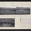
This is not the remains of a broch (as published on OS 6" map, Caithness, 2nd ed., 1908) but an enclosure measuring some 20.0m E-W by 10.0m and situated on the edge of a slight embankment on the N side of the Langwell Water. The enclosure would appear to have been divided into two compartments and is formed by an earth-and-stone bank 0.7m maximum height. The W compartment is divided by a slight earth-and-stone bank. The E compartment seems to contain a hut circle at its N end; there is the entrance to an earth-house in the S bank. The passage is stone-lined and roofed, and appears to be in very good condition while the enclosure itself is very dilapidated.
Visited by OS (W D J), 13 June 1960.
The amorphous remains of a homestead generally as described and planned by previous OS field surveyor. It is so obscured by peat and dense heather that no structural details are exposed, apart from the souterrain, and the plan remains indeterminate. The entrance to the souterrain is partly blocked by debris, but the passage, stone-lined and lintelled, is accessible; it angles steeply downwards in a SW direction for 4.0m before turning to the S for a further 4.0m, at which point the descending roof-line and water which fills the lower part of the souterrain meet, barring further exploration. No corbelled end-chamber can be seen.
Some 60m to the E, on the same natural shelf as the homestead, are the vague footings of a hut circle set into the base of a slope. It measures 8.0m in diameter within a wall 0.3m high, but masked by an overburden of peat and heather. There is a gap in the S, probably an entrance. A boulder within the hut circle has probably fallen from a boulder wall on the hillslope to the N of the hut; this wall, extending for a short distance to the W and E, is probably contemporary with the hut. Otherwise, there is no trace of associated land use.
Surveyed at 1:10,000.
Visited by OS (N K B), 11 November 1982.

