
Following the launch of trove.scot in February 2025 we are now planning the retiral of some of our webservices. Canmore will be switched off on 24th June 2025. Information about the closure can be found on the HES website: Retiral of HES web services | Historic Environment Scotland
Ulbster


Head Dyke (Post Medieval), Rig And Furrow (Medieval) - (Post Medieval), Sheepfold (Period Unassigned), Township (Period Unassigned)
Site Name Ulbster
Classification Head Dyke (Post Medieval), Rig And Furrow (Medieval) - (Post Medieval), Sheepfold (Period Unassigned), Township (Period Unassigned)
Canmore ID 75211
Site Number NC91NE 81
NGR NC 962 184
Datum OSGB36 - NGR
Permalink http://canmore.org.uk/site/75211


- Council Highland
- Parish Kildonan
- Former Region Highland
- Former District Sutherland
- Former County Sutherland
NC91NE 81 962 184.
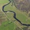
Ulbster: A deserted crofting township comprising the ruins of seven houses, some with gardens, and several enclosures, situated on a terrace above the river floodplain. The floodplain is occupied by contemporary run rig extending over about fifteen hectares. The railway bisects and destroys a part of the township.
Visited by OS (NKB) 17 November 1976.
A township, comprising sixteen unroofed building, eight enclosures and a head-dyke is depicted on the 1st edition of the OS 6-inch map (Sutherland 1879, sheet lxxviii). One roofed building, six unroofed buildings and a sub-divided enclosure are shown on the current edition of the OS 1:10,560 map (1964).
Information from RCAHMS (AKK) 16 October 1995.

