
Pricing Change
New pricing for orders of material from this site will come into place shortly. Charges for supply of digital images, digitisation on demand, prints and licensing will be altered.
Braeval


Enclosure(S) (Period Unassigned), Farmstead (Period Unassigned)
Site Name Braeval
Classification Enclosure(S) (Period Unassigned), Farmstead (Period Unassigned)
Canmore ID 75134
Site Number NC90NW 32
NGR NC 920 083
NGR Description Centred NC 920 083
Datum OSGB36 - NGR
Permalink http://canmore.org.uk/site/75134

- Council Highland
- Parish Loth
- Former Region Highland
- Former District Sutherland
- Former County Sutherland
NC90NW 32 centred 920 083.
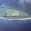
Centred at NC 9207 0830: Four rectangular buildings in varying ruinous states, each with an enclosure abutting it to the N. Running W-E in front of the houses is a track, and immediately to the S is a large enclosure.
(The buildings are shown roofed on OS 6-inch map, Sutherland, 1st ed. (1879), sheet xcviii.)
J Harden 1991.
At Braeval, there are three long buildings, on an NE to SW alignment, associated with four or five, short parallel strips of enclosed ground, as well as a number of smaller structures. A single building with enclosures lies about 150m to the E. The ground to the N of the farmstead was surveyed as part of a pre-afforestation survey at Kintradwell and one small rectangular building and a number of small cairns were noted.
S Carter and J Rideout (Headland Archaeology) 3 March 1999; NMRS MS 899/132, no.2; S Carter 1999

