
Brora, Wilkhouse


Building (Period Unassigned), Inn (18th Century), Pool (Period Unknown), Stock Enclosure (18th Century), Button(S) (Bone)(Period Unassigned), Coin(S) (17th Century), Comb (Bone)(Period Unassigned), Inorganic Material(S) (Glass)(18th Century), Organic Material (Bone)(Period Unknown), Pin(S) (Period Unassigned), Pipe (Smoking)(S) (Clay)(Period Unassigned), Tile(S) (Slate)(Period Unassigned), Unidentified Pottery(S) (18th Century)
Site Name Brora, Wilkhouse
Classification Building (Period Unassigned), Inn (18th Century), Pool (Period Unknown), Stock Enclosure (18th Century), Button(S) (Bone)(Period Unassigned), Coin(S) (17th Century), Comb (Bone)(Period Unassigned), Inorganic Material(S) (Glass)(18th Century), Organic Material (Bone)(Period Unknown), Pin(S) (Period Unassigned), Pipe (Smoking)(S) (Clay)(Period Unassigned), Tile(S) (Slate)(Period Unassigned), Unidentified Pottery(S) (18th Century)
Canmore ID 75131
Site Number NC90NW 29
NGR NC 930 081
Datum OSGB36 - NGR
Permalink http://canmore.org.uk/site/75131


- Council Highland
- Parish Loth
- Former Region Highland
- Former District Sutherland
- Former County Sutherland
NC90NW 29 930 081
This site was previously recorded at NC 924 074 which corresponded to the location shown on Roy's map, however this grid reference does not match the location as shown on the 1st edition of the OS 6-inch map (1879) and the site has now been relocated at the grid reference shown.
(Undated) information in NMRS.
(NC 924 074) Wilkhouse: shown by Roy (nothing here on modern maps).
W Roy 1747-55, sheet 36/1
An unroofed building is depicted on the 1st edition of the OS 6-inch map (Sutherland 1879, sheet xcviii), but it is not shown on the current edition of the OS 1:10,560 map (1964).
Information from RCAHMS (SAH), 30 October 1995.
Excavation (23 May 2017 - 3 June 2017)
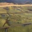
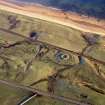
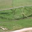
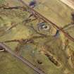
NC 93078 08138 GUARD Archaeology and Clyne Heritage Society ran a community excavation, 23 May – 3 June 2017, on a known drovers’ inn, Wilkhouse, located c4.7km N of Brora. The project involved volunteers from the Clyne Heritage Society, the local scout group, the local primary school and other volunteers from the local and wider community. The excavations revealed previously unknown details about the construction of Wilkhouse and a neighbouring building, Gilchrist, of similar 18th-century origin. Wilkhouse was found to have walls bonded with mortar with a mortar render applied internally for part of the building. A total of three hearths were uncovered, two in one gable, one in the other. The floor consisted of compacted natural sand
with stone paving around the pair of hearths in the NE gable and some paving external to the entrance. Gilchrist was predominantly of dry stone construction with longer and flatter stones, possibly sourced from the nearby broch. There was evidence of some stone paving within the Gilchrist
building along with an accumulation of dark occupation deposits.
Aside from the main buildings, there were a number of enclosures around each building, with a large pool thought to be used for the watering of livestock being driven along this NE routeway. The drove road location was not established due to numerous sinuous pathways masking its original location, the coastline here is also a relict dune system and is therefore prone to erosion.
The artefact assemblage included 18th-century pottery and glass, slate roof tile fragments, dress-making pins, bone buttons, a bone comb fragment, clay pipe fragments and animal bone. The metal detecting survey recovered a total of 98 objects, 15 of which were coins ranging in date from 17th to 19th century with one token also recovered. A number of other as yet unidentified objects were also recovered.
Archive: NRHE (intended)
Funder: Private individual
Warren Bailie – GUARD Archaeology Ltd
(Source: DES, Volume 18)

