
Sundaywell Moor


Burnt Mound (Prehistoric), Cairnfield (Prehistoric), Settlement (Prehistoric)
Site Name Sundaywell Moor
Classification Burnt Mound (Prehistoric), Cairnfield (Prehistoric), Settlement (Prehistoric)
Canmore ID 75034
Site Number NX78SE 43
NGR NX 7933 8446
Datum OSGB36 - NGR
Permalink http://canmore.org.uk/site/75034


- Council Dumfries And Galloway
- Parish Dunscore
- Former Region Dumfries And Galloway
- Former District Nithsdale
- Former County Dumfries-shire
Field Visit (28 August 1991)
NX78SE 43 7934 8446.
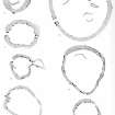
This oval scooped homestead is situated towards the rear of a terrace at the N fringe of the heavily dissected ground on Sundaywell Moor and at the S edge of more level, partially cleared, ground. It measures 15.1m from NNW to SSE by 13.2m transversely within a boulder-faced wall 1.8m in thickness and up to 1.2m in height. The entrance passage, which slopes into the interior, lies on the NW and is flanked by two large boulders (the N stone now dislodged). There is a scatter of boulders in the interior. On the E there is what may be an original gap in the wall which gives access to a partially enclosed platform, measuring 6m from WNW by 4.4m transversely, the function of which is uncertain. (Nith 50) Scattered around the homestead, on the edges of terraces and on knolls, there are at least seven small cairns forming part of a wider scatter of small cairns across Sundaywell Moor and measuring up to 5m in diameter and 0.4m in height. In a gully to the NE of the homestead there is a C-shaped burnt mound (NX 7937 8448, Nith 151) which measures 5.5m from NE to SW by 4m transversely and 0.5m in height, and opens out to the SE. (Nith 50, 151)
Visited by RCAHMS (DCC) 28 August 1991.
Measured Survey (4 October 1991)
RCAHMS surveyed the homestead, burnt mound and small cairns at Sundaywell Moor (NX78SE 43) on 4 October 1991 at a scale of 1:250. The resultant plan was redrawn in ink at a scale of 1:250.

