
Pricing Change
New pricing for orders of material from this site will come into place shortly. Charges for supply of digital images, digitisation on demand, prints and licensing will be altered.
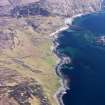
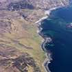
Skye, Allt Na Peighinn


Building(S) (Period Unassigned), Rig And Furrow (Medieval) - (Post Medieval)
Site Name Skye, Allt Na Peighinn
Classification Building(S) (Period Unassigned), Rig And Furrow (Medieval) - (Post Medieval)
Canmore ID 74734
Site Number NG61NW 17
NGR NG 623 168
Datum OSGB36 - NGR
Permalink http://canmore.org.uk/site/74734


- Council Highland
- Parish Strath
- Former Region Highland
- Former District Skye And Lochalsh
- Former County Inverness-shire
NG61NW 17 623 168
Lying in a very exposed position high above the W bank of the Allt na Peighinn and overlooking an area of rig cultivation on the E bank of
the burn are the ruinous remains of two structures being:-
1. (NG 6238 1681). A sub-rectangular house, its SE end being rectangular with a central doorway while the NW is rounded with a radius of 3m overall. Dimensions are 10.5m NW-SE by 5.1m NE-SW over walls 1.1m thick.
2. (NG 6239 1684). The second structure lies 18m to the N and is of circular construction. It measures 9.5m in diameter over walls 1.4m thick. This structure is much more ruinous than (1) and may be considerably older.
A short length of turf dyke lies 20m to the E.
Visited by IJ, CS and GH, 3 April 1990.

