
Crink Law


Boundary Bank (Medieval) - (18th Century)
Site Name Crink Law
Classification Boundary Bank (Medieval) - (18th Century)
Canmore ID 74650
Site Number NT60NE 68
NGR NT 6601 0818
NGR Description From NT 6514 0853 to NT 6775 0848
Datum OSGB36 - NGR
Permalink http://canmore.org.uk/site/74650


- Council Scottish Borders, The
- Parish Southdean
- Former Region Borders
- Former District Roxburgh
- Former County Roxburghshire
Field Visit (10 January 1992)
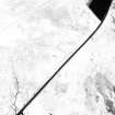
NT60NE 68 660 081.
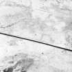
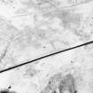
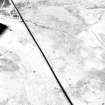
This boundary, which comprises a ditch, some 5m in breadth and 0.5m in depth with an upcast bank on both sides, runs for some 3km from the top of the Jordan Sike (NT 6514 0853) to a plantation at the top of another sike at NT 6775 0848. Its course takes it over the SW flank of Crink Law, across the Kill Burn at NT 6688 0797, where it turns to the NE to run through the plantations and improved fields to the S of Lethem.
Near its W end (NT 6528 0841) the ditch bifurcates, but the southerly of the two branches only runs on for some 50m to the WSW.
Little can be said of its relationships except at its W end where a later boundary bank (NT60NE 38.01, Phase 2) runs across it from N to S and the rig on the hillslopes above the Jordan Sike to the W respects it. It is thus earlier than this phase of cultivation.
Visited by RCAHMS (PJD) 10 January 1992.
Sbc Note
Visibility: This is an upstanding earthwork or monument.
Information from Scottish Borders Council

