
Following the launch of trove.scot in February 2025 we are now planning the retiral of some of our webservices. Canmore will be switched off on 24th June 2025. Information about the closure can be found on the HES website: Retiral of HES web services | Historic Environment Scotland
Bannockburn House


Country House (17th Century)
Site Name Bannockburn House
Classification Country House (17th Century)
Alternative Name(s) Bannockburn House Policies
Canmore ID 74600
Site Number NS88NW 1
NGR NS 80885 88881
Datum OSGB36 - NGR
Permalink http://canmore.org.uk/site/74600


First 100 images shown. See the Collections panel (below) for a link to all digital images.
- Council Stirling
- Parish St Ninians
- Former Region Central
- Former District Stirling
- Former County Stirlingshire
NS88NW 1.00 80885 88881
NS88NW 1.01 NS 81098 88996 Old Dovecot
NS88NW 1.02 NS 80898 88976 Gate-piers
NMRS REFERENCE
Owner: Miss A.E.T. Mitchell.
Architect: additions 1880.
(Undated) information in NMRS.
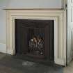
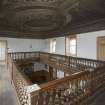
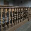
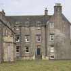
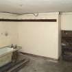
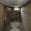
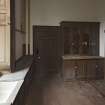
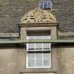
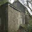
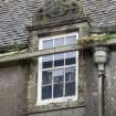
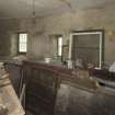
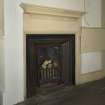
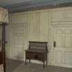
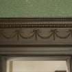
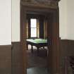
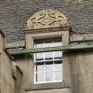
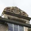
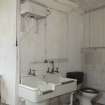
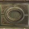
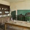
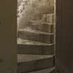
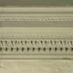
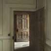
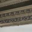
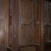
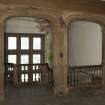
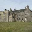
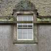
17th century - 18th century, Victorian additions. Good ceilings. 3 storey E shaped plan. Centre section has 5 window pattern with projecting porch. 2 symmetrical 3 storey gabled wings with crowsteps. Later 2 storey building to right. Upper windows have decorated pediments. (Historic Environment Scotland List Entry)
Probably commissioned circa 1675 by Hugh Paterson shortly after he bought the estate from Andrew, 3rd Lord Rollo (Gifford and Walker).
Laser Scanning (23 January 2017 - 8 February 2017)
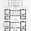
In early 2017 HES scanned the exterior of Bannockburn House to provide control for a set of floor plans. A single scan of the ground floor interior was also carried out.
Test Pit Survey (3 August 2018 - 5 August 2018)
NS 81016 89041 A programme of metal detecting and test
pitting was undertaken, 3–5 August 2018, which aimed to
define the possible presence of the Jacobite army camp
prior to the siege of Stirling and the battle of Falkirk in
January 1746. The work was achieved with the help of 26
volunteers from the local community and the Bannockburn
House Trust.
A total of six test pits (1 x 1m) were hand excavated across
an area of garden to the N of Bannockburn House. A total of
two pits and four postholes were revealed in three test pits.
Finds included 74 iron artefacts, most of them unidentifiable
due to poor preservation, 7 copper alloy coins, buttons, and
a single lead pistol bullet. No evidence of occupation prior to
the 19th century was found.
Archive: NRHE (intended)
Funder: Bannockburn House Trust
Anthony Byledbal – GUARD Archaeology Ltd
(Source DES Vol 19)
Archaeological Evaluation (24 July 2019 - 25 July 2019)
Addyman Archaeology undertook an evaluation in the grounds of Bannockburn House as part of a wider programme of works associated with the development of a Conservation Plan and Masterplan for the house and grounds. Bannockburn House is a late 17th century Category A Listed Building and lies within the Battle of Sauchieburn Historic Battlefield and just to the north of Bannockburn Historic Battlefield. Three trenches were excavated: two within the field along the eastern boundary of the estate, where research by Trust volunteers suggested the route of a former trackway associated with coal workings in the area and one within the walled garden to investigate the location of the former central path. Trench 1 revealed a kerbed and cambered metalled trackway running along the eastern boundary of the estate towards an avenue of poplars and also crossed the line of a drainage ditch associated with a former rockery. At the northern end of the trench the road overlay an earlier wall and associated foundation cut. The wall was only partially exposed but appeared to be the corner of a building. Trench 2 revealed a less well-preserved continuation of the trackway as well as a later surface, probably related to a more recent track. Both tracks were above a layer of mixed midden material, which contained part of the neck and strap handle of a green glazed redware jug dating to the 16th-17th century. Trench 3 within the walled garden identified a narrow cinder topped path within the trench, broadly in line with the path shown on the first edition Ordnance Survey map. The results have demonstrated the survival of a probable 18th century trackway within the eastern field, along with the tentative possibility of earlier settlement evidence.
Information from OASIS ID: addymana1-362421 (P Karsgaard) 2019
Project (30 October 2019 - 1 November 2019)
NS 80885 88881 A geophysical survey was undertaken within a field just to the E of the walled garden at Bannockburn House (Canmore ID: 74600) on 30 October to 1 November 2019. This survey forms part of a programme of assessments prior to the construction of poly tunnels and the planting of shelter belts and an orchard (see also DES 2019, 200).
Survey over an area of 0.66ha was conducted with resistance and gradiometry. The resistance data was collected at 0.5 by 0.5m intervals and the gradiometry at 0.25m intervals along traverses 1m apart.
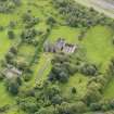
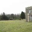
Bannockburn House is a late 17th-century mansion with 19th-century additions. The house and its policies are of cultural significance, having important associations with medieval battles, Jacobite history and the tartan weaving industry.
Previous excavations/trial trenching had taken place in the field and were still open at the time of survey. The excavations revealed the remains of trackways, which may be associated with the former coal roads in this area and possible coal workings to the S. Although no finds were recovered, map evidence suggests this may have 18th century origins if it is related to the former coal routes and activity in the area. Within the southern trench a possible building was revealed. A large fragment of 16th-/17th-century pottery was recovered from one of the trenches and, together with other finds derived from midden deposits, appears to have been used to infill a natural dip in the ground. The size and condition of the pottery indicates that it has not travelled far, which suggests settlement in the vicinity.
The resistance data is dominated by broad low resistance responses in the S of the area and corresponds with a pond/open water channel that took water from the rockery in the formal garden to the W to the drain in the SE of the field.
In the S of the survey area a low circular earthwork is visible. A magnetic anomaly and a resistance anomaly coincide with portions of the low bank suggesting possible revetment. Within the centre of the earthwork a strong magnetic response within a low resistance anomaly has been recorded. It is not clear if this is an indication of mine capping/entrance or simply an accumulation of other modern material. Additional high resistance anomalies have been recorded in the area which may suggest possible structural remains, although a natural origin cannot be dismissed.
A range of responses has been recorded along the eastern limits of the survey area, which show some correlation with the recent excavations but the responses are intermittent and ephemeral. This is likely to be due to insufficient contrast between the features and the surrounding material. Strong magnetic responses and high resistance values have been recorded adjacent to the field boundary. The origin of the magnetic material is not known, but it has a clear southern limit and may be due to midden deposits used to level the ground.
A broad well-defined area of high resistance has been recorded in the northern half of the field. The well-defined edges and rectilinear form of the anomalies would normally suggest possible structural remains or some form of anthropogenic activity. However, in this case it is thought that this may be due to natural variations in the subsurface.
Archive: Rose Geophysical Consultants
Funder: Bannockburn House Trust
Susan Ovenden – Rose Geophysical Consultants
(Source: DES Volume 21)
Magnetometry (30 October 2019 - 1 November 2019)
NS 80885 88881 Magnetometry survey.
Archive: Rose Geophysical Consultants
Funder: Bannockburn House Trust
Susan Ovenden – Rose Geophysical Consultants
(Source: DES Volume 21)
Earth Resistance Survey (30 October 2019 - 1 November 2019)
NS 80885 88881 Resistance survey.
Archive: Rose Geophysical Consultants
Funder: Bannockburn House Trust
Susan Ovenden – Rose Geophysical Consultants
(Source: DES Volume 21)
Trial Trench (10 July 2023)
An archaeological trial trench evaluation was undertaken on behalf of Bannockburn House Trust at Bannockburn House, Bannockburn, Stirling. The work was carried out on the 10th July 2023 in order to fulfil the requirements of planning permission for the creation of a car park as part of a larger development project at Bannockburn House (planning application ref: 23/00168/FUL). A total of 6 trenches were excavated which totaled 108 sq. m, approximately 5% of the area to be disturbed during construction of the car park. No significant archaeological remains or deposits were uncovered.

