
Stirling, 29 St John Street, Erskine Marykirk Church


Church (19th Century), Youth Hostel (20th Century)
Site Name Stirling, 29 St John Street, Erskine Marykirk Church
Classification Church (19th Century), Youth Hostel (20th Century)
Canmore ID 74544
Site Number NS79SE 176
NGR NS 79264 93583
Datum OSGB36 - NGR
Permalink http://canmore.org.uk/site/74544


- Council Stirling
- Parish Stirling
- Former Region Central
- Former District Stirling
- Former County Stirlingshire
NS79SE 176.00 79264 93583
NS79SE 176.01 79286 93618 Erskine Monument
After demolition and some ground reduction a watching brief revealed dark brown garden soil beneath the 19th century church floor. This deposit contained no finds and no evidence of earlier occupation of the site was encountered.
Sponsors: SUAT, HS
R Cachart 1991.
NMRS REFERENCE:
Architect: Allen Johnstone 1824-6
Field Visit (9 September 1954)
NS79SE ("Ch.") 792 936
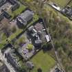
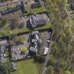
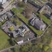
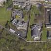
Erskine Marykirk, St. John Street, Stirling.
The church that was built about 1740 for the Rev. Ebenezer Erskine's seceding congregation (1) stood on the SW. side of St. John Street. This church was superseded in 1826 by the existing structure, known as the Erskine Marykirk, which stands rather further to the SW., at the brink of the Castle Rock, and leaves the site of Erskine's church as an open space in front of it. Erskine, who died in 1754, was buried under the floor of his church, and his tomb may now be seen in the open space, overlooked by the elaborate Classical monument illustrated in PI. 50 B. This monument, which was erected in 1859 (2) to the design of Messrs. Peddie and Kinnear, Edinburgh, stands about 30 ft. high on a base 15 ft. 6 in. square, and bears the name EBENEZER ERSKINE on the lintel course on the NE. side.
The existing church measures 90 ft. externally from NE. to SW. by 70 ft. transversely. The sides and SW. end are of random rubble, harled, and the windows, of which there are three superimposed pairs in each sidewall and two, both tall, at the SW. end, have segmental heads and backset margins. The NE. end (PI. 40 A) is of black whinstone rubble brought to courses, and has its central portion advanced and finished in a pediment supported by four flat pilasters of freestone. Similar pilasters rise at the ends of the facade. The main entrance is in the centre of the advanced portion and is flanked by windows; there is another entrance to right and to left, and five windows are placed symmetrically above. All these openings are round-headed and have freestone dressings. The eaves-course and parapet are also of freestone, and there is a hipped slated roof.
The doors give entrance to a lobby, in the centre, from which stairs rise to the gallery. Above the domed portion of the lobby is a session-room, reached by a side-stair off the stair to the gallery on the right. The body of the church is curved at the NE. end, the congregation at both levels facing towards a pulpit at the SW. end.
RCAHMS 1963, visited 9 September 1954.
(1) TSNHAS (1907-8), 102. See also RCAHMS 1963, p. 8 above.
(2) TSNHAS (1908-9), 76.

