
Dallachy Airfield


Airfield (20th Century)
Site Name Dallachy Airfield
Classification Airfield (20th Century)
Alternative Name(s) Raf Dallachy; Moor Of Dallachy; Bogmoor; Nether Dallachy
Canmore ID 74207
Site Number NJ36SE 30
NGR NJ 3650 6350
NGR Description Centred NJ 3650 6350
Datum OSGB36 - NGR
Permalink http://canmore.org.uk/site/74207


- Council Moray
- Parish Bellie
- Former Region Grampian
- Former District Moray
- Former County Morayshire
NJ36SE 30.00 centred 3650 6350
For cropmarks (including that of a possible souterrain) within the area of the airfield, see NJ36SE 54.
NJ36SE 30.01 NJ 36011 63299 Control Tower
NJ36SE 30.02 NJ 3770 6264 Bomb Store
NJ36SE 30.03 NJ 35697 63058 Commemorative Monument
NJ36SE 30.04 NJ 36492 62838 Operations Block
NJ36SE 30.05 Centred NJ 36744 62691 Military Camp (Quarters)
NJ36SE 30.06 Centred NJ 35610 62639 Hospital (Sick Quarters)
NJ36SE 30.07 Centred NJ 36331 62335 Military Camp (Communal)
NJ36SE 30.08 Centred NJ 36157 62151 Military Camp (Mess)
NJ36SE 30.09 Centred NJ 36540 62414 Military Camp (Mess)
NJ36SE 30.10 Centred NJ 36900 62160 Military Camp (Quarters)
NJ36SE 30.11 Centred NJ 36391 62049 and NJ 36638 61892 Military Camps (WAAF Quarters)
NJ36SE 30.12 Centred NJ 36104 61603 Military Camp (Quarters)
NJ36SE 30.13 Centred NJ 35826 61776 Military Camp (Quarters)
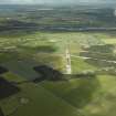
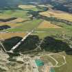
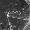
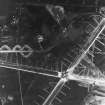
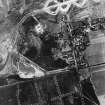
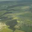
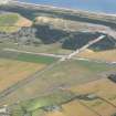
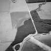
A disused World War II airfield built 1942-3, now almost entirely cleared of its original buildings. The watch tower still stands; old operations block stands beside approach road. Appears on Jasair aerial photograph 607.88: 098, flown 6 May 1988.
Survey by J A Guy for Historic Scotland, 18 November 1992.
J Guy 1992; NMRS MS/712/6.
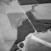
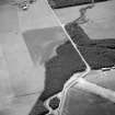
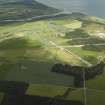
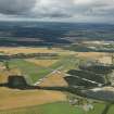
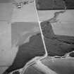
The control tower (watch tower) stands in the middle of a cultivated field about 390m NE of the Monument to the Dallachy Strike Wing (NJ36SE 30.03), and the concrete track leading to it survives. The operations block would appear to have been recently demolished. What may be an associated concrete and brick water tower remains at Spey Bay (NJ 35465 65011). All other buildings around the airfield would appear to have been removed. However, most of the concrete runways, perimeter tracks and taxiways are still extant, though heavily overgrown.
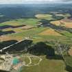
The remains of the bomb store lies in the Wood of Auchenreath.
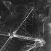
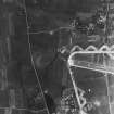
The airfield is visible on vertical air photographs taken in 1945 (106G/UK 750, 5019-5023 and 5081-5085, flown 31 August 1945). The aerial phtographs show the airfield at the full extent with runways, taxiways and perimeter track along with the aircraft hangars (T type and several Blister type), many ancilliary buildings and the bomb store. In addition, the photographs also show that to the N of the airfield was a large area of anti-landing ditches in an area annotated 'The Links' on OS maps. This area is now covered by more recent afforestation.
Visited by RCAHMS (DE), 29 August 2007
Watching Brief (13 February 2019 - 19 February 2019)
(NJ 3660 6393) A walkover survey and a watching brief were undertaken, 13-19 February 2019, on part of the former airfield (Canmore ID: 74207) that was due for development as a sand and gravel quarry. There was no evidence of any surviving structural features relating to the airfield with the exception of the runway and the perimeter areas of concrete. It would appear probable that most if not all of this area was in grass when the airfield was in use. Since then it had been covered by close planted conifers.
Archive: Moray SMR and NRHE
Funder: Limehillock Quarries
H K Murray ̶ Murray Archaeological Services Ltd
(Source: DES Vol 20)
OASIS ID: mas1-371918

