
Pricing Change
New pricing for orders of material from this site will come into place shortly. Charges for supply of digital images, digitisation on demand, prints and licensing will be altered.
Lewis, Stornoway, Stornoway Airport; Highlands And Islands Airports Limited


Airfield (20th Century), Airport (20th Century)
Site Name Lewis, Stornoway, Stornoway Airport; Highlands And Islands Airports Limited
Classification Airfield (20th Century), Airport (20th Century)
Alternative Name(s) Mealabost; Melbost Golf Links; Raf Stornoway Airfield; Stornoway Aerodrome
Canmore ID 74205
Site Number NB43SE 10
NGR NB 4585 3337
NGR Description Centred NB 4585 3337
Datum OSGB36 - NGR
Permalink http://canmore.org.uk/site/74205


First 100 images shown. See the Collections panel (below) for a link to all digital images.
- Council Western Isles
- Parish Stornoway
- Former Region Western Isles Islands Area
- Former District Western Isles
- Former County Ross And Cromarty
NB43SE 10.00 centred 4585 3337
NB43SE 10.01 centred NB 46251 33031 Aircraft Hangars; Buildings; Huts (Technical site)
NB43SE 10.02 centred NB 44932 33310 Bomb Store
NB43SE 10.03 centred NB 46093 33786 Aircraft Hangars
NB43SE 10.04 centred NB 45295 32770 Military Camp
NB43SE 10.05 centred NB 45133 32484 Military Camp
NB43SE 10.06 centred NB 44863 32349 Military Camp
NB43SE 10.07 centred NB 44989 31983 and NB 45177 31963 Military Camps
NB43SE 10.08 centred NB 46215 32231 Aircraft Hangar; Buildings; Huts
NB43SE 10.09 centred NB 44617 32903 Military Camp
NB43SE 10.10 centred NB 45421 32488 Aircraft Hangar; Buildings; Huts; Power Station
NB43SE 10.11 NB 46174 33190 Control Tower
Stornoway airfield absorbed the pre-war airstrip on Melbost Golf Links. The RAF Station HQ was established at Stornoway in April 1941.
D J Smith 1983.
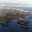
The airfield is situated to the E of Stornoway and W of Mealabost. The airfield is still in use and there are many WW II structures still extant around the perimeter. However, many of the WW II buildings around the terminal have recently been demolished and new ones built.
J Guy 2002; NMRS MS 810/12, 56-9
The airfield is visible on vertical air photographs taken in 1946 (CPE/Scot/UK 189, 4076-4080, flown 10 October 1946), which shows the main runways, later extended, aircraft hangars, technical area, bomb store, dispersal areas and the dispersed accommodation camps. The airfield had by the end of the war been provided with a total of ten hangars.
The remains of a few of these can still be traced around the airfield, but most of the wartime buildings were recently cleared during the upgrading of the airfield to create Stornoway Airport. In addition, several postwar NATO buildings can also be seen around the airfield perimeter. Information from locals suggest that many of the underground bunkers and tanks have recently been filled in. The control tower (NB 46174 33190), has been extensively modified.
The accommodation camps were mainly N and S of the Sandwick Road with a further three centred at NB 4530 3275, NB 4515 3250 and NB 4490 3235, the latter two annotated as 'Camp site' (disused), on the OS 1:1000 scale maps (1975, 1985).
One post 1945 building was noted at NB 46240 32156, presently empty and externally painted in mid-green and would appear to be from the NATO occupation period.
Information from RCAHMS (DE), August 2005

