Badbea
Township (19th Century)
Site Name Badbea
Classification Township (19th Century)
Alternative Name(s) Lat 304
Canmore ID 7415
Site Number ND01NE 2
NGR ND 087 197
NGR Description ND 0820 1920 to ND 0930 2040
Datum OSGB36 - NGR
Permalink http://canmore.org.uk/site/7415
- Council Highland
- Parish Latheron
- Former Region Highland
- Former District Caithness
- Former County Caithness
ND01NE 2 0820 1920 to 0930 2040
Location formerly entered as ND 087 197.
Badbea is now a deserted village perched on the cliff edge just N of the Ord. It was from Badbea, an eviction settlement, that some of the earliest settlers for New Zealand came.
Sutherland County Guide [nd].
ND 087 197. Badbea: The remains of a deserted township consisting of buildings and enclosures in various states of dilapidation. A modern monument, erected in 1911, commemorates the former inhabitants of Badbea.
Visited by OS (W D J), 30 May 1960.
(ND 087 197) Badbea (NAT)
OS 6" map, (1964)
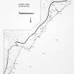
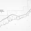
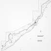
Badbea is a deserted township signposted as a historic site and viewpoint. It comprises the ruins of sixteen buildings, several remaining to gable height, which range from 30.0 by 4.5m to 7.0 by 4.5m. There are also a number of enclosures, a network of field walls, but no recognisable corn-drying kilns.
A monument at the site, erected in 1911, lists the former inhabitants of Badbea; one person it is stated was born there in 1806, and there was one tenant remaining in 1911. A plaque recently set up at the approach to the township states that it was settled by "twelve families whose homes in Sutherland had been destroyed during the Highland Clearances".
Visited by OS (N K B), 8 November 1982.
A township, comprising fifteen roofed buildings, four of which are long buildings, three unroofed buildings, twenty enclosures and field walls, is depicted on the 1st edition of the OS 6-inch map (Caithness 1877, sheet xliv).
Twenty four unroofed buildings and eleven enclosures are shown on the current edition of the OS 1:10,560 map (1964).
Information from RCAHMS (AKK), 23 November 1995.
Publication Account (1995)
Small groups of ruined croft houses and outbuildings are dispersed at intervals along the diffrop for a distance of some 2km. The path leads to a monumental stone pillar set on the ruins of one longhouse. This was erected in 1911 by Donald Sutherland from New Zealand, in memory of his father Alexander Sutherland, who was born at Badbea in 1806 and left for New Zealand in 1839. It also bears the names of some other early inhabitants. The history of the settlement is obscure, but traditionally it as founded by tenants evicted in some of the earliest clearances. People from Langwell in Caithness are said to have arrived in about 1793, followed by others from Berriedale and Ousedale. Some stayed temporarily before accepting free passages to America, others permanently. The site is very exposed, though not infertile, and the population gradually left for other parts.
The crofthouses are strung out along the flattish ground on the cliff top, each with its own patch of cultivated ground still showing as grassy islands in the heather. The separate crofts which now seem so typical to us, contrast with the older layout at Rosal (no. 29), where the houses were grouped round the common infield. The buildings are very similar, with longhouses set running down the slope, the lower end a byre, and other small structures, barns, stables and kailyards arranged haphazardly. The houses may originally have had central hearths, but latterly at least they had chimneys in the gable walls, as seen in the building south of the monument. The large slabs in its gable were to reduce the weight on the tintel over the hearth.
Most of the other crofts lie north of the monument and were once linked by a track. In 1871 the settlement was described by the Ordnance Survey as 'district of some six crofts of a few acres each'; by then it had perhaps already diminished. Originally there were rather more houses, bur it is difficult to reconcile the surviving remains with traditions that there were some 28 families at Badbea in the early 19th century, and some 60 to 100 people living there in 1847.
Information from ‘Exploring Scotland’s Heritage: The Highlands’, (1995).


