
North Berwick Law


Naval Signal Station (18th Century)
Site Name North Berwick Law
Classification Naval Signal Station (18th Century)
Canmore ID 73938
Site Number NT58SE 66
NGR NT 55637 84251
Datum OSGB36 - NGR
Permalink http://canmore.org.uk/site/73938


![Signal Station. Inscription of G R [Georgius Rex].](http://i.rcahms.gov.uk/canmore/l/DP00281306.jpg)


![Signal Station. Inscription of G R [Georgius Rex].](http://i.rcahms.gov.uk/canmore/s/DP00281306.jpg)


- Council East Lothian
- Parish North Berwick
- Former Region Lothian
- Former District East Lothian
- Former County East Lothian
NT58SE 66 5565 8424
The ruin of a stone watch-house erected during the Napoleonic war.
G Shiel, undated.
NT 556 842 (centre) A desk-based assessment and survey were undertaken of North Berwick Law. A total of 13 sites or groups of sites were identified during the course of the field survey. A detailed plot was made of the later prehistoric settlement (NMRS NT58SE 10) on the S flank of the Law. Previously unrecognised elements of the Napoleonic-period signalling station (NMRS NT58SE 66) on the summit were traced. An element of the early 18th-century plantation on the NE side of the Law was also identified.
An archaeological evaluation and watching brief were subsequently carried out on the NE slope of North Berwick Law prior to a programme of tree planting. A hand-dug trench, 6 x 1m, was excavated across a bank, thought to be the boundary of a plantation established in 1707. The profile of the bank was recorded. Two pieces of flint and a copper-alloy buckle were found within topsoil deposits. Twelve test pits, 0.5 x 0.5m, were excavated across the area to be planted. No archaeological deposits or finds were encountered.
Full details lodged with the NMRS.
Sponsors: North Berwick Community Council, East Lothian Council.
C Lowe and J Morrison 2001
Note (November 2017)
Signalling, Suspicion and Secret Codes
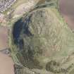
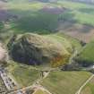
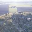
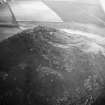
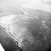
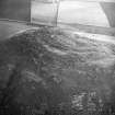
The conical profile of North Berwick Law is a familiar landmark presiding over the plains of East Lothian and crowned by a fibreglass copy of a whalebone arch. Less familiar perhaps, even to those who make the climb to the top, are the remains of a signal station immediately adjacent and the important role it played in helping to defend the nation from sea borne invasion. Now used by tourists and day-trippers as a platform to take in the panoramic views of the Firth of Forth, few are aware of the history beneath their feet.
The station was constructed at the beginning of the 19th century as part of a chain of naval signal posts that stretched along the Scottish coast from Calton Hill in Edinburgh to St Abbs. It belonged to a wider network of stations that ran along the coasts of Britain and Ireland serving as an alert system during the wars with France and her allies. The stations were used to monitor the seaways for enemy vessels and forewarn the Royal Navy of any potential threat. Coded messages were communicated from the signal station using a system of flags, pennants and balls hoisted on a flagstaff. The location of a ship was communicated by giving its position in relation to coastal features or local landmarks. The messages were relayed between stations, including harbours such as Dunbar and Leith, where Naval command was based. Once the message had been received, a Navy ship was sent to intercept the suspect vessel.
The station would have been operated by a team of four men commanded by a Naval Lieutenant. The men were recruited locally and were usually fishermen or boatmen. With younger men committed to the army and navy, the signal men were individuals considered ‘unsuitable for ship service’, generally on account of their age. Although life on watch was basic and harsh, the men were supplied with some items of domestic comfort. An inventory notes the supply of tables, chairs, coal, candles and even a bath stove for the commanding officer, together with a flagstaff, mast, pennants and signalling balls.
When the war with France ended in 1815 so too did the need for the coastal signal stations. While part of the system continued to be used by the Revenue service to monitor ship movements for customs and excise purposes, most were abandoned or dismantled. Although the lifespan of these buildings was short, those that survive are evidence of Scotland’s role in naval history when, in the words of 19th century writer James Miller, ‘East Lothian had now most decidedly turned her ploughshare into a sword’.
‘Tokens of time and tempest’
The end of the war with France sealed the fate for the signal station on North Berwick Law and its demise was described some thirty years later by the Reverend Robert Balfour Graham in the New Statistical Account of Scotland:
‘The ruins on the top are only of modern date, and were the residence of the party – (a naval officer and three assistants,) in charge of the signal station established thereon during the late war, and dismantled on the return of peace. The erections are all unroofed, and yearly accumulating the usual interest and tokens of time and tempest.’
Almost a decade later, its continuing decline is depicted on the 1854 1st edition of the Ordnance Survey where three roofless buildings are annotated ‘Old Telegraph Station (in ruins)’.
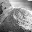
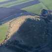
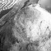
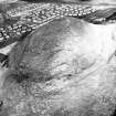
Today the remains of the signal station can be seen just below the summit, built into the rock on a small terrace on the north side of the hill. Given such an exposed location they are remarkably well preserved. A survey by Headland Archaeology Ltd in 2001 identified several of the structures associated with the signal station, including two small outbuildings, one of which may have been a privy, as well as a yard containing the foundations for the signalling flagstaff. The layout of the buildings has a close parallel with that at St Abb’s, which was part of the same signal station chain.
As the saying goes ‘History has a habit of repeating itself’ and the summit of North Berwick Law was once again utilised when threatened by wartime invasion. In the 20th century, when war exploded across Europe, an observation post was built just below its 19th century predecessor, once again keeping watch over the Firth of Forth.
Leanne McCafferty, Data Projects Manager, Historic Environment Scotland
Further Reading:
Frank Kitchen The Napoleonic War Coast Signal Stations, The Mariner’s Mirror, Vol. 76, Issue 4, 1990
James Miller The Lamp of Lothian, Or, the History of Haddington, 1844
The Rev. Robert Balfour Graham Parish of North Berwick. The New Statistical Account of Scotland, 1845
Field Visit (19 February 2018)
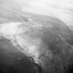
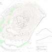
The remains of an Admiralty Coastal Signal Station dating from 1798 to 1814 are located to the E of the summit of North Berwick Law, and comprise an accommodation block, a building platform, an enclosure, a small hut that may be a latrine, a flagstaff, the remains of fixings near the summit, and a pathway leading down the NE flank of the hill. It once formed part of a national coastal network constructed to provide warning of French ships, in particular privateers, sailing into the Firth of Forth (Kitchen 1990; Knight 2014; Morris and Barclay 2017).
The accommodation block (6.1, NT 55637 84251) is set against bedrock and measures about 4.3m square within mortared walls 0.6m in thickness, built from rubble quarried from the immediate surroundings. Three of the four walls survive, the NW gable standing to 4.3m in height and the NE wall to 2.2m. There is a central doorway (1m wide) in the centre of the NE side and there was once a fireplace in the NW wall (Hendry 2011a; 2011b).
About 10m to the E of this building there is a level garden enclosure (6.2b) that measures up to 11.5m from ENE to WSW by 10.5m transversely over a wall reduced to grass-grown footings about 0.8m thick and no more than 0.5m high. The decayed stump of a flag pole stands at the centre of the enclosure, and a decaying timber with iron nautical-style fittings, some 10m long, lies just to the NE. At the NW corner of the enclosure there is a small building that has probably acted as a latrine (6.2a, NT 55652 84249). Entered from the WSW, it measures 2.3m from NNW to SSE by 1.5m transversely over random rubble walls 0.34m thick and up to 1m high. A section of mortared wall, recorded in 2000 (MS 1039/72), and lying 7m to the S of the enclosure was not visible. About 4.5m to the NNW of the latrine there is a building platform, presumably the site of a timber building. It measures approximately 4m square and has been dug into the slope on the S to a depth of 0.6m. Exposed bedrock 7m to the SE of the enclosure bears the letters G R in gothic script: this stands for Georgius Rex, presumably George III (1738—1820). Immediately to the SE, where bedrock has been quarried, there are two further graffiti: ‘M.M.E.R.’ and ‘AH – EA’. The summit of the Law bears a series of former mast fixings, pits and rock cuttings, some of which hold severed iron stumps set in molten lead and were probably used to secure the signalling equipment. Finally, the station was accessed by a narrow path which zig-zags down the NE flank of the hill: its distinctive shape led to it being known as the ‘M-walk’ (OS Name Book No. 24, 41; No. 25, 67).
Historical Note:
A recent review has recorded that eight pre-fabricated timber Coastal Signal Stations were constructed at Chatham Dockyard in 1798 for use in Scotland (Morris and Barclay 2017). The Stations were briefly abandoned during the peace between 1802 and 1803, but an estate map of 1804 (NRS RHP 1726) clearly depicts a small group of four buildings, an enclosure, a beacon and a flagstaff. In 1819 it was noted that, before its abandonment, ‘the officer of the station had a small garden, which produced vegetables in great perfection’ (Webster 1819, 75; cf. Loudon 1806, 484).
By 1839, the ruins of the station were described as ‘the residence of the party – (a naval officer and three assistants,) in charge of the signal station established thereon during the late war, and dismantled on the return of peace.’ (NSA, Vol. 2, 318). Three unroofed buildings and an enclosure are shown on the 1st edition of the OS 6-inch map (Haddingtonshire Sheet 2, 1854; OS Name Book No. 50, 25). Most other references are derivative of the 1839 account, although a recent review records that a Lieutenant Leyden commanded the station at one time, and the former existence of a beacon to supplement the system of signal flags and balls (Hendry 2011a).
The network of stations along the Scottish east coast included, from east to west: Calton Hill, Mill Stairs (unlocated), Port Seaton, Skid Hill, North Berwick Law, Dunbar Harbour, Blackcastle Hill, St Abb’s Head and Dow Law (Miller 1844, 174; Lavery 2012; Morris and Barclay 2017, 112). North Berwick Law is by far the best preserved, but surface remains also survive at St Abb’s Head (Canmore ID 330146) and Blackcastle Hill (NT 7228 7240).
Visited by HES Survey and Recording (GFG, JRS) 19 February 2018.
(NBL 6.1 – 6.3)

