
Pricing Change
New pricing for orders of material from this site will come into place shortly. Charges for supply of digital images, digitisation on demand, prints and licensing will be altered.
Birsay, Brough Road


Cist (Period Unassigned)
Site Name Birsay, Brough Road
Classification Cist (Period Unassigned)
Canmore ID 73550
Site Number HY22NW 59
NGR HY 2464 2808
Datum OSGB36 - NGR
Permalink http://canmore.org.uk/site/73550


- Council Orkney Islands
- Parish Birsay And Harray
- Former Region Orkney Islands Area
- Former District Orkney
- Former County Orkney
HY22NW 59 2464 2808.
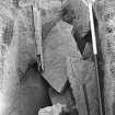
Upright stones, visible in sand, were excavated in 1976, and though there was no remaining skeleton, the bone fragments found between the stones were human, and may represent all that is left of a skeleton lost to the sea (Cutting 3). Biological material in the Royal Museum of Scotland (RMS).
C D Morris 1978a, 1979h, 1979i, 1989.
Excavation (1976)
Upright stones, visible in sand, were excavated in 1976, and though there was no remaining skeleton, the bone fragments found between the stones were human, and may represent all that is left of a skeleton lost to the sea (Cutting 3). Biological material in the Royal Museum of Scotland (RMS).
C D Morris 1978a, 1979h, 1979i, 1989.

