
Broomy Law; Black Mount


Cursus (Neolithic)
Site Name Broomy Law; Black Mount
Classification Cursus (Neolithic)
Alternative Name(s) Melbourne
Canmore ID 73422
Site Number NT04SE 48
NGR NT 08564 42955
NGR Description from NT 07804 45319 to NT 08564 42955
Datum OSGB36 - NGR
Permalink http://canmore.org.uk/site/73422


- Council South Lanarkshire
- Parish Biggar
- Former Region Strathclyde
- Former District Clydesdale
- Former County Lanarkshire
Field Visit (18 April 2013 - 26 June 2013)
This cursus monument is situated at Melbourne crossroads some 7km to the northeast of Biggar at the intersection of the A702 and the A721. From here two ridges of hills extend NE framing routes leading towards Edinburgh, including that of the Roman Road from Crawford to Inveresk (NT04NE 55; NT 04SE 45), while to the S, SW and SE the land is more open and undulating. The monument traverses the valley between the summits of Black Mount on the NNW and Broomy Law on the SSE running for a distance of almost 2.5km. Both terminals survive, that on the NNW being round-ended while that on the SSE squared, and significant stretches of the sides remain as upstanding earthworks, characterised by a bank and external ditch. As these descend the slopes into improved farmland they disappear. The lines of the ditches in several sectors can be traced on aerial photographs as intermittent linear soilmarks and cropmarks, albeit that the ENE side appears the most continuous.
Some 250m of the NNW end remains visible, with its ditches between 83m and 85m apart, and apparently converging as they ascend the steep slope towards the terminal. The ENE side is the most clearly defined and is neither straight nor regular, instead displaying minor changes of alignment along its course. The bank is relatively uniform in appearance, and is broad and flat-topped but little more than 0.2m high. It is heather-grown, contrasting with the verdant green grass of the ditch, which ranges from 0.1m to 0.4m in depth. The ditch also varies considerably in breadth and appears to be segmented, comprising a series of adjoining linear hollows. There is one break in the ditch, at NT 07879 45256, which coincides with a dislocation in its alignment, though the bank is continuous across the gap. The bank thickens around the terminal and incorporates the crest of the spur that forms the local summit on this flank of Black Mount, but is rather curiously offset asymmetrically to the topography on its ENE side. An entrance 3.5m wide is situated on the crest of this summit and a shallow circular depression can be seen just outside it, though whether modern disturbance or the top of an ancient pit is impossible to determine without excavation. From this point the perimeter curves round to the S, petering out after a distance of no more than 18m on a natural scarp that forms a prominent feature extending its line down the slope. After a break of 145m, however, the ditch and bank pick up again and can be followed for a further 68m before they disappear once more. The fragmentary nature of this side suggests that it may be incomplete, but it is possible that this side is in any case much slighter and deliberately utilises the local topography to follow the edge of the scarp that planes downslope from the summit.
On the opposite side of the valley, towards the upper limits of the improved fields, the sides of the cursus emerge as shallow scarps marking the inner edges of the ditches and set some 98m apart. These narrow to 75m where they reach the terminal a further 260m upslope on the grassy summit of Broomy Law. Both sides are sinuous and wriggle as they climb the steep slope, the bank low and broad measuring 2.5m in thickness and 0.2m in height, and the ditch shallow and segmented, ranging from 0.1m to 0.25m in depth and between 1.5m and 2.2m in breadth. Like the NNW terminal, the WSW side is rather slighter in its appearance, almost disappearing short of the field of improved pasture at the foot of the slope. Nevertheless, it is probably continuous, whereas the ENE side is broken by two entrances, the lower at NT 08567 43053 some 5m wide, and the upper at NT 08573 43026 3.4m wide.
Like the NNW terminal, the bank around the SSE end thickens and an entrance 2.4m wide in the terminal lies offset to its axis, though here to the ENE. On this side of the gap, the bank has also been superimposed onto an earlier mound, which can be traced as far as the corner of the terminal some 27m to the ENE. Measuring up to 6m in breadth by 0.6m in height adjacent to the entrance, the mound seems to taper towards the ENE and the flanking ditch here is much deeper and more irregularly segmented that anywhere else along the perimeter. There is also a clearly defined berm between the foot of the cursus bank and the lip of the ditch, indicating that the form of this sector of the ditch is probably associated with the initial construction of the mound. While the location of this mound, tucked just below the highest point on Broomy Law, is common enough amongst Neolithic barrows, there is no evidence that this is the remains of a long barrow as such, particularly as there is no trace of a corresponding ditch along its N side. Nevertheless, it clearly formed an important factor in setting out the cursus itself.
The summit of Broomy Law has been semi-improved and the farmer at Brownsbank recalls that the area was disc-harrowed some forty years ago. There are traces of furrows and grooves in and around the terminal, some of which may relate to this improvement though others may be earlier, and what is probably the line of an old fence line can be seen cutting through the WSW corner, perhaps accounting for the shallow nature of the ditch and the levelling of the bank at this point. The most prominent groove lies within this corner, appearing as a narrow ditch with no trace of an upcast bank, which runs downslope to converge on the WSW side of the cursus but stops just short of any intersection; the date and function of this feature are uncertain. Numerous scoops and hollows outside the ENE side of the monument are probably tree throws, though the farmer has no recollection of woodland on this part of the hill, and none is shown on any earlier maps of the area.
Visited by RCAHMS (ARG, DCC, SPH), 18 April 2013
Project (18 April 2013 - 26 June 2013)
The discovery of a new cursus monument at Melbourne Crossroads by Strat Halliday, formerly of RCAHMS, was brought to the attention of Dave Cowley and Angela Gannon during a field visit in April 2013. The cursus is the longest so far discovered in Scotland and extends across a valley from Black Mount in the NNW to Broomy Law in the SSE covering a distance of almost 2.5km. The earthworks of both terminals survive, together with significant stretches of the sides, characterised by a bank and external ditch. Such was the importance of the discovery that RCAHMS took the opportunity to survey the monument by mapping the visible extent using differential GPS, and supplementing this with information derived from historic aerial photographs, particularly in the central section where the monument appeared to have been levelled by agricultural improvements or afforestation. The SSE terminal was also recorded in greater detail by terrestrial laser scanner and traditional plane table to explore and analyse the phased construction of the monument. This terminal was first recorded on oblique aerial photographs in 1991 when it was classified as field boundaries and possible clearance cairns. This classification has since been revised, a full description of the monument has been written and further aerial photographs have been catalogued.
Information from HES Survey and Recording 9 November 2018
Measured Survey (26 June 2013)
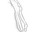
RCAHMS surveyed the south terminal of Broomy Law cursus monument on 26 June 2013 with plane-table and alidade at a scale of 1:00. The resultant plan was redrawn in vector graphics software.
Change Of Classification (31 January 2014)
This monument was classified formerly as FIELD BOUNDARY(S) and CLEARANCE CAIRN (POSSIBLE) but has subsequently been reinterpreted as the SSE terminal of a Neolithic cursus.
Information from RCAHMS (ARG), 31 January 2014
Archaeological Evaluation (9 March 2015 - 10 March 2015)
NT 08580 43009 A geophysical survey and evaluation excavation were carried out, 9–10 March 2015, to assess archaeological potential relating to Melbourne Cursus, W of Melbourne Crossroads. Two areas were targeted with geophysical survey, the first to the N of the A721 and the second to the S of the A702. A single trench was also excavated over the bank and ditch on the ENE side of the cursus, close to the southern terminal. The results from the c5ha gradiometer survey were inconclusive, and it can be suggested that the instruments were affected by magnetic noise caused by the local geology
and subsequently were unable to clearly identify potential archaeological remains.
In the excavation trench, evidence of the structure of the monument was revealed. The structural remains comprised a low broad bank with a turf core. A ditch extended along the exterior of the cursus bank. A shallow pit lay outside of the ditch. No artefacts were retrieved during the excavations, but soil samples that may produce datable organics and samples for soil micromorphological analysis were collected.
Archive: NRHE
Funder: RCAHMS
Jamie Humble and Graeme Cavers – AOC Archaeology Group
(Source: DES, Volume 17)

