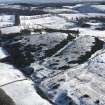
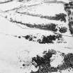
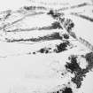
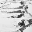
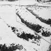
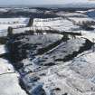
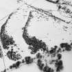
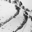
Accessibility

Font Size

100% 150% 200%

Background Colour

Default Contrast
Close Reset

Gormyre Hill

Enclosure (Period Unassigned)

Site Name Gormyre Hill

Classification Enclosure (Period Unassigned)

Alternative Name(s) Wester Gormyre

Canmore ID 73383

Site Number NS97SE 95

NGR NS 9755 7259

Datum OSGB36 - NGR

Permalink http://canmore.org.uk/site/73383

Ordnance Survey licence number AC0000807262. All rights reserved.
Canmore Disclaimer. © Bluesky International Limited 2025. Public Sector Viewing Terms

Toggle Aerial | View on large map

Digital Images

General oblique aerial view centred on the remains of the enclosures and rig, taken from the WNW.
General oblique aerial view centred on the remains of the enclosures and rig, taken from the WNW.Gormyre Hill, oblique aerial view, taken from the NW, centred on an enclosure.Gormyre Hill, oblique aerial view, taken from the NNE, centred on an enclosure.Oblique aerial view.Gormyre Hill, oblique aerial view, taken from the NNW, centred on an enclosure.Oblique aerial view.Oblique aerial view.Oblique aerial view.General oblique aerial view centred on the remains of the enclosures and rig, taken from the W.Oblique aerial view.Gormyre Hill, NS97SE 95, Ordnance Survey index card, RectoOblique aerial view.

Administrative Areas

  • Council West Lothian
  • Parish Torphichen
  • Former Region Lothian
  • Former District West Lothian
  • Former County West Lothian

Archaeology Notes

NS97SE 95 9755 7259

See also NS97SE 5.

Information to follow.

RCAHMS (KB) 13 December 1999 .

References

MyCanmore Image Contributions


Contribute an Image

MyCanmore Text Contributions