
Pricing Change
New pricing for orders of material from this site will come into place shortly. Charges for supply of digital images, digitisation on demand, prints and licensing will be altered.
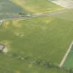
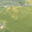
Inverness To Fort George Military Road


Military Road (18th Century)
Site Name Inverness To Fort George Military Road
Classification Military Road (18th Century)
Canmore ID 73315
Site Number NH74NW 68
NGR NH 7200 4767
NGR Description NH 7000 4610 to 7420 4999
Datum OSGB36 - NGR
Permalink http://canmore.org.uk/site/73315


- Council Highland
- Parish Inverness And Bona
- Former Region Highland
- Former District Inverness
- Former County Inverness-shire
NH74NW 68 7000 4610 to 7420 4999
The modern road (A96) follows the line of the old military road, passing Allanfearn and joining the route now followed by the B9039 in the vicinity of Newton at NH 7383 4865.
W Taylor 1976.

