
Pricing Change
New pricing for orders of material from this site will come into place shortly. Charges for supply of digital images, digitisation on demand, prints and licensing will be altered.
Carpow


Cropmark (Period Unknown)
Site Name Carpow
Classification Cropmark (Period Unknown)
Canmore ID 73228
Site Number NO21NW 90
NGR NO 20930 18160
NGR Description Centred NO 20930 18160
Datum OSGB36 - NGR
Permalink http://canmore.org.uk/site/73228


- Council Perth And Kinross
- Parish Abernethy (Perth And Kinross)
- Former Region Tayside
- Former District Perth And Kinross
- Former County Perthshire
NO21NW 90 centred 20930 18160
See also NO21NW 62 and NO21NW 89.
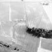
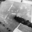
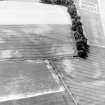
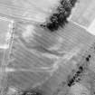
Aerial photography (RCAHMSAP 1990) has recorded a short L-shaped length of ditch about 100m NE of the Roman legionary fortress NO21NW 24.00. The date and purpose of this feature remain unclear.
Information from RCAHMS (JRS), 4 February 1997.
Aerial Photographic Transcription (31 December 1993)
An aerial transcription was produced from oblique aerial photographs. Information from Historic Environment Scotland (BM) 31 March 2017.

