
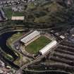
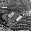
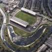
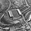
Glasgow, Maryhill, General


General View (Period Unassigned)
Site Name Glasgow, Maryhill, General
Classification General View (Period Unassigned)
Canmore ID 72985
Site Number NS56NE 572
NGR NS 5670 6852
Datum OSGB36 - NGR
Permalink http://canmore.org.uk/site/72985


- Council Glasgow, City Of
- Parish Glasgow (City Of Glasgow)
- Former Region Strathclyde
- Former District City Of Glasgow
- Former County Lanarkshire
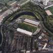
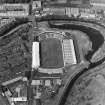
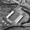
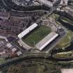
MARYHILL
Maryhill Road, previously known as Gairbraid Street, was built as a turnpike in 1753, when the only industries were textile manufacture, bleaching and calico printing. Gairbraid was one of the large estates dating from the Reformation. The Forth & Clyde Canal crossed the Kelvin on Whitworth's famous aqueduct in 1787 and the Glasgow branch canal reached Port Dundas in 1790. Mary Hill, heiress of Gairbraid, feued land along the canal and the turnpike in the 1790s, but the population of her development, supposedly named after her, was only about 2,000 in 1841. By 1856 railways were beginning to overtake canal transport and the Burgh was established. The 19th century saw rapid industrial development, with iron foundries on both sides of the canal, most others to the east. Several saw mills; glass and bottle works in the 1870s; Alexander Ferguson's Lead & Colour Works, 1874; George MacLellan's Glasgow Rubber Works, 1876; and several chemical works from the 1880s. The population had grown to 24,000 in 1881, and when Glasgow absorbed the Burgh in 1891 it had reached nearly 40,000. By then Maryhill Road was lined with sandstone tenements. Many more were built by John Campbell McKellar's speculative building company from 1890 to 1910. Slum clearance in the 1930s was followed in the 1960s by demolitions for the lower-density Comprehensive Redevelopment of North Woodside and for the construction of an Expressway to remove a bottleneck on the commuter route from Bearsden and Milngavie (which is also the tourist route to the Trossachs), leaving a population dramatically reduced to around 25,000.
Taken from "Greater Glasgow: An Illustrated Architectural Guide", by Sam Small, 2008. Published by the Rutland Press http://www.rias.org.uk


