 |
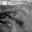
On-line Digital Images |
SC 379142 |
RCAHMS Aerial Photography |
Oblique aerial view. |
|
Item Level |
|
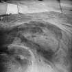 |
On-line Digital Images |
SC 1759844 |
RCAHMS Aerial Photography |
Oblique aerial view. |
1989 |
Item Level |
|
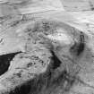 |
On-line Digital Images |
SC 1759888 |
RCAHMS Aerial Photography |
Oblique aerial view. |
1990 |
Item Level |
|
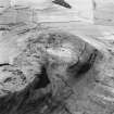 |
On-line Digital Images |
SC 1759889 |
RCAHMS Aerial Photography |
Oblique aerial view. |
1990 |
Item Level |
|
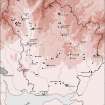 |
On-line Digital Images |
SC 1917621 |
Records of the Royal Commission on the Ancient and Historical Monuments of Scotland (RCAHMS), Edinbu |
Map showing the distribution of Neolithic and Bronze Age funerary monuments (cists, round cairns, burials, ring-ditches and long cairns) in Annandale and Eskdale. Published in Eastern Dumfriesshire: an archaeological landscape. |
1996 |
Item Level |
|
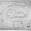 |
On-line Digital Images |
DP 380548 |
Records of the Royal Commission on the Ancient and Historical Monuments of Scotland (RCAHMS), Edinbu |
Publication drawing; site plan of Burnswark showing Roman and native works |
c. 1915 |
Item Level |
|


