
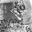
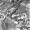
Ravensby House


Fort (Period Unknown)(Possible)
Site Name Ravensby House
Classification Fort (Period Unknown)(Possible)
Alternative Name(s) Barry Burn
Canmore ID 72859
Site Number NO53SW 43
NGR NO 5370 3460
Datum OSGB36 - NGR
Permalink http://canmore.org.uk/site/72859


- Council Angus
- Parish Barry
- Former Region Tayside
- Former District Angus
- Former County Angus
Note (26 May 2015 - 31 May 2016)
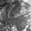
Cropmarks have revealed the northern part of a fortified enclosure backing onto the E side of the shallow gully cut by the Barry Burn. The position is probably a terrace at the foot of the ESE end of a low ridge dropping in from the ENE. Broadly speaking the enclosure is probably D-shaped, but the only sector of the perimeter that is well defined is a single ditch some 5m in breadth that extends N from an entrance on the E for about 30m before turning sharply back to the lip of the gully 30m to the W. There are traces of small rectangular features in the inteiror, but it is unclear how much further the enclosure extends to the SSE.
Information from An Atlas of Hillforts of Great Britain and Ireland – 31 May 2016. Atlas of Hillforts SC3078
Aerial Photographic Transcription (23 June 2017)
An interpretative transcription, or mapping, of information on oblique aerial photographs was produced on 23 June 2017.

