
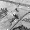
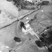
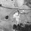
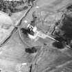
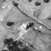
Niddry Castle


Hollow Way (Period Unassigned)
Site Name Niddry Castle
Classification Hollow Way (Period Unassigned)
Canmore ID 72667
Site Number NT07SE 40
NGR NT 0945 7435
Datum OSGB36 - NGR
Permalink http://canmore.org.uk/site/72667


- Council West Lothian
- Parish Kirkliston (West Lothian)
- Former Region Lothian
- Former District West Lothian
- Former County West Lothian
NT07SE 40 0945 7435
W of Niddry Castle is the fragment of a hollow-way 5m wide, aligned roughly WNW-ESE. It is apparently a fragment of a road passing the S side of the castle and heading towards Niddry Farm.
Sponsors: COWL (Bathgate), CBT (Edinburgh).
C A Kelly 1989.

