
Niddry Castle


Rig And Furrow (Medieval) - (Post Medieval)
Site Name Niddry Castle
Classification Rig And Furrow (Medieval) - (Post Medieval)
Canmore ID 72666
Site Number NT07SE 39
NGR NT 095 742
Datum OSGB36 - NGR
Permalink http://canmore.org.uk/site/72666


- Council West Lothian
- Parish Kirkliston (West Lothian)
- Former Region Lothian
- Former District West Lothian
- Former County West Lothian
NT07SE 39 095 742
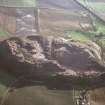
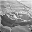
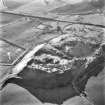
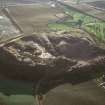
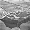
Descending the slope S of Niddry Castle, in a NE direction, are at least eight metre wide rigs with distinctive S-bend curves.
Sponsors: COWL (Bathgate), CBT (Edinburgh)
C A Kelly 1989.

