
Pricing Change
New pricing for orders of material from this site will come into place shortly. Charges for supply of digital images, digitisation on demand, prints and licensing will be altered.
Upcoming Maintenance
Please be advised that this website will undergo scheduled maintenance on the following dates:
Thursday, 9 January: 11:00 AM - 3:00 PM
Thursday, 23 January: 11:00 AM - 3:00 PM
Thursday, 30 January: 11:00 AM - 3:00 PM
During these times, some functionality such as image purchasing may be temporarily unavailable. We apologise for any inconvenience this may cause.
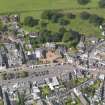
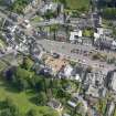
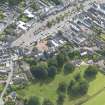
Moffat, General


Burgh (Medieval), Town (Period Unassigned)
Site Name Moffat, General
Classification Burgh (Medieval), Town (Period Unassigned)
Canmore ID 72572
Site Number NT00NE 31
NGR NT 0851 0520
NGR Description Centred NT 0851 0520
Datum OSGB36 - NGR
Permalink http://canmore.org.uk/site/72572


- Council Dumfries And Galloway
- Parish Moffat
- Former Region Dumfries And Galloway
- Former District Annandale And Eskdale
- Former County Dumfries-shire
NT00NE 31 centred 0851 0520
Erected burgh of regality in 1648
G S Pryde 1965.
Visible on OS vertical air photographs 73/431/163-4.
Small town in upper Annandale, founded as a burgh of barony in 1643 which gained an early reputation as a spa; the medicinal properties of the sulphurous Moffat Well (NT00NE 33), 2km NE, were recognised by 1657. From the 1760's, major improvements were made to the town; most of the existing houses were rebuilt and the High Street was widened in 1771-2.
The burgh's popularity as a spa and resort was enhanced in 1847 by the opening of the nearby Beattock Railway Station (NT00SE 64).
J Gifford 1996.
NMRS REFERENCE:
Moffat Housing Scheme:
Architect: Reginald Fairlie, 1921 [with Reid and Forbes]
EXTERNAL REFERENCE:
National Register of Archives for Scotland
NRA(s) 393 bundle 165 (Johnstone of Annandale)
Note of expenses for making Lord Annandale's kitchen wind and water tight (pulling braken, casting divots and thatching), 6 January 1724
Photographic Survey (September 1964)
Photographic survey of buildings in Moffat by the Scottish National Buildings Record in September 1964.

