
Following the launch of trove.scot in February 2025 we are now planning the retiral of some of our webservices. Canmore will be switched off on 24th June 2025. Information about the closure can be found on the HES website: Retiral of HES web services | Historic Environment Scotland
Scotston


Field System (Period Unassigned), Hut Circle(S) (Prehistoric)
Site Name Scotston
Classification Field System (Period Unassigned), Hut Circle(S) (Prehistoric)
Canmore ID 72569
Site Number NN94SW 7
NGR NN 904 432
Datum OSGB36 - NGR
Permalink http://canmore.org.uk/site/72569


- Council Perth And Kinross
- Parish Little Dunkeld
- Former Region Tayside
- Former District Perth And Kinross
- Former County Perthshire
NN94SW 7 904 432
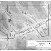
This enclosed settlement and field-system is situated some 700m NNW of Scotston farm. There are the remains of at least eight circular houses, surviving as low turf-covered banks, ranging in size from 10m to 18m in diameter. One of the houses is a double-walled 'Dalrulzion' type. There are also the remains of at least three other possible structures. The field system comprises the extensive remains of field boundary banks and approximately 110 field clearance cairns, many of which are in linear arrangements.
Information from SDD (HBM) December 1990.
Field Walking (17 January 2012 - 15 May 2012)
A walkover survey was carried out over the entire development area at Griffin Wind Farm. Eighteen previously unrecorded sites were identified during the walkover, some of which lay within the construction footprint of the development. The sites comprised 38 individual structures including 22 shieling huts, two possible hut-circles, two enclosures, three hollow features, one bank, three shooting butts, four clearance cairns and one possible funerary cairn.
Information from Oasis (headland1-118953) 2 November 2012
Desk Based Assessment (15 May 2012 - 22 June 2012)
Following an initial survey at Calliachar Wind Farm a series of sites located within the construction footprint were excavated prior to the start of the construction work. Two of the excavated structures, a clearance cairn and a stone bank, were associated with the nearby scheduled prehistoric settlement and field system near Scotston. The remaining sites including a man-made hollow containing a series of occupation deposits, six shielings and three areas of occupation deposits were located within the turbine area at Calliachar. Two Neolithic flint arrowheads were retrieved from one of the areas of occupation, another contained an iron bloom.
Information from Oasis (headland1-130771) 2 November 2012

