Accessibility

Font Size

100% 150% 200%

Background Colour

Default Contrast
Close Reset

Milton Of Kilravock

Ring Ditch(S) (Period Unassigned)

Site Name Milton Of Kilravock

Classification Ring Ditch(S) (Period Unassigned)

Canmore ID 72189

Site Number NH85SW 37

NGR NH 837 510

Datum OSGB36 - NGR

Permalink http://canmore.org.uk/site/72189

Ordnance Survey licence number AC0000807262. All rights reserved.
Canmore Disclaimer. © Bluesky International Limited 2025. Public Sector Viewing Terms

Toggle Aerial | View on large map

Digital Images

Oblique aerial view of the cropmarks of the ring ditches, looking NNW.
Oblique aerial view of the cropmarks of the ring ditches, looking NNW.Oblique aerial viewOblique aerial view.Milton of Kilravock, oblique aerial view, taken from the SW, showing the cropmarks of a ring-ditch and two possible ring-ditches in the bottom half of the photograph, and a further ring-ditch in the top centre.Oblique aerial view.Oblique aerial view of the cropmarks of the ring ditches, looking WNW.Oblique aerial view.Oblique aerial view.Oblique aerial view of the cropmarks of the ring ditches, looking WNW.Milton of Kilravock, oblique aerial view, taken from the S, showing the cropmarks of a ring-ditch and two possible ring-ditches in the bottom half of the photograph, and a further ring-ditch in the top centre.Oblique aerial view of the cropmarks of the ring ditches, looking NW.Oblique aerial view.

Administrative Areas

  • Council Highland
  • Parish Croy And Dalcross (Nairn)
  • Former Region Highland
  • Former District Nairn
  • Former County Nairn

Archaeology Notes

NH85SW 37 837 510.

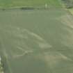
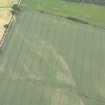
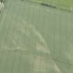
NH 8363 5112 Site identified as part of a desk based assessment and walk over survey. A ring ditch cropmark noted from oblique aerial photographs held by the RCHAMS taken in 1989. No trace of this feature was located during the walk over survey.

Jacobs Babtie, 2005.

References

MyCanmore Image Contributions


Contribute an Image

MyCanmore Text Contributions